Scarcelli geodata
Scarcelli (Calabria) is a populated place; located in Italy in Europe/Rome (GMT+2) time zone. With population of 1,700 people, there are 4667 cities with bigger population in this country. Compared to other cities in Italy, 90.8% of cities are located further ↑North; 92.9% of cities are located further ←West and 80.9% of cities have higher elevation than Scarcelli. Note1


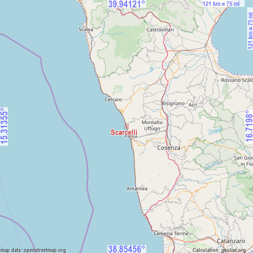
Scarcelli GPS coordinates[2]
39° 24' 0" North, 16° 1' 0.012" East
| Map corner | latitude | longitude |
|---|---|---|
| Upper-left | 39.94121°, | 15.31355° |
| Center: | 39.4°, | 16.01667° |
| Lower-right: | 38.85456°, | 16.7198° |
| Map W x H: | 120.8×120.8 km | = 75.1×75.1mi |
| max Lat: | 47.04031° ⇑90.8% North |
| Scarcelli: | 39.4° |
| min Lat: | ⇓9.2% South 35.50142° |
| min Long | Scarcelli | max Long |
| 6.69888° | 16.01667° | 18.48682° |
| W 92.9%⇐ | ⇒7.1% E |
Elevation
Elevation of Scarcelli is 46 m = 151 ft, and this is 260.7 m = 855 ft below average elevation for this country.
| Max E: |
2085 m = 6841 ft | 80.9% |
| Avg. | 306.7 m = 1006 ft | |
| Scarcelli | 46 m = 151 ft | |
Min E: |
-4 m = -13 ft | 19.1% |
See also: Italy elevation on elevation.city.
Geographical zone
Scarcelli is located in North temperate zone (between Tropic of Cancer and the Arctic Circle). Distance of this Northern Tropic circle is 1775 km =1102.9 mi to South.| Distance of | km | miles | from Scarcelli |
|---|---|---|---|
| North Pole | 5626.2 | 3496 | to North |
| Arctic Circle | 3020.3 | 1876.7 | to North |
| Tropic Cancer | 1775 | 1102.9 | to South |
| Equator | 4380.9 | 2722.2 | to South |


Nearby cities:
15 places around Scarcelli: (largest is in red/bold)
• Acquappesa
11.9 km =7.4 mi,  333°
333°
• Amendola
12.1 km =7.5 mi,  121°
121°
• Bucita
11.5 km =7.1 mi, 120°
• Fuscaldo
1.9 km =1.2 mi,  32°
32°
• Guardia Piemontese
7.5 km =4.7 mi,  348°
348°
• Lattarico
11 km =6.8 mi,  59°
59°
• Marina
7.7 km =4.8 mi,  336°
336°
• Marina di Fuscaldo
2.8 km =1.7 mi, 342°
• Montalto Uffugo
11.9 km =7.4 mi,  88°
88°
• Paola
4.5 km =2.8 mi,  157°
157°
• Rota Greca
11.2 km =7 mi,  48°
48°
• San Benedetto Ullano
9.7 km =6 mi,  71°
71°
• San Filippo-Battendieri
12.3 km =7.6 mi, 341°
• San Lucido
10.5 km =6.5 mi, 162°
• San Vincenzo la Costa
12.2 km =7.6 mi,  108°
108°
Sources, notices
• [Note1] Compared only with cities in Italy existing in our database
• [Src1] Map data: © OpenStreetMap contributors (CC-BY-SA)
• [Src2] Other city data from geonames.org with taken over terms of usage.
• [Src3] Geographical zone / Annual Mean Temperature by Robert A. Rohde @ Wikipedia
