San Lucido geodata
San Lucido (Calabria) is a seat of a third-order administrative division; located in Italy in Europe/Rome (GMT+2) time zone. With population of 4,194 people, there are 2286 cities with bigger population in this country. Compared to other cities in Italy, 91.2% of cities are located further ↑North; 93.1% of cities are located further ←West and 72% of cities have higher elevation than San Lucido. Note1


San Lucido GPS coordinates[2]
39° 18' 36.432" North, 16° 3' 11.412" East
| Map corner | latitude | longitude |
|---|---|---|
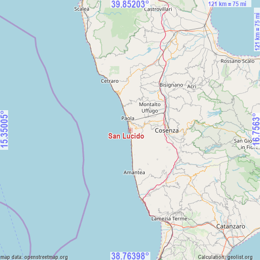
| Upper-left | 39.85203°, | 15.35005° |
| Center: | 39.31012°, | 16.05317° |
| Lower-right: | 38.76398°, | 16.7563° |
| Map W x H: | 121×121 km | = 75.2×75.2mi |
| max Lat: | 47.04031° ⇑91.2% North |
| San Lucido: | 39.31012° |
| min Lat: | ⇓8.8% South 35.50142° |
| min Long | San Lucido | max Long |
| 6.69888° | 16.05317° | 18.48682° |
| W 93.1%⇐ | ⇒6.9% E |
Elevation
Elevation of San Lucido is 88 m = 289 ft, and this is 218.7 m = 718 ft below average elevation for this country.
| Max E: |
2085 m = 6841 ft | 72% |
| Avg. | 306.7 m = 1006 ft | |
| San Lucido | 88 m = 289 ft | |
Min E: |
-4 m = -13 ft | 28% |
See also: Italy elevation on elevation.city.
Geographical zone
San Lucido is located in North temperate zone (between Tropic of Cancer and the Arctic Circle). Distance of this Northern Tropic circle is 1765 km =1096.7 mi to South.| Distance of | km | miles | from San Lucido |
|---|---|---|---|
| North Pole | 5636.2 | 3502.2 | to North |
| Arctic Circle | 3030.3 | 1882.9 | to North |
| Tropic Cancer | 1765 | 1096.7 | to South |
| Equator | 4370.9 | 2716 | to South |


Nearby cities:
15 places around San Lucido: (largest is in red/bold)
• Amendola
8.1 km =5 mi,  62°
62°
• Bucita
8 km =5 mi, 58°
• Falconara Albanese
4.9 km =3 mi,  142°
142°
• Fiumefreddo Bruzio
8.4 km =5.2 mi,  169°
169°
• Marano Marchesato
10.4 km =6.5 mi,  88°
88°
• Marano Principato
10.5 km =6.5 mi,  97°
97°
• Paola
6.1 km =3.8 mi,  346°
346°
• Rende
11.2 km =7 mi,  77°
77°
• San Biase
10.1 km =6.3 mi,  161°
161°
• San Fili
8.5 km =5.3 mi,  67°
67°
• San Vincenzo la Costa
10.4 km =6.5 mi,  53°
53°
• Scalo Ferroviario
7.2 km =4.5 mi,  175°
175°
• Scarcelli
10.5 km =6.5 mi,  342°
342°
• Scaro-Reggio-Scornavacca-Vardano
9.1 km =5.7 mi, 175°
• Torremezzo di Falconara
4.6 km =2.9 mi, 174°
Sources, notices
• [Note1] Compared only with cities in Italy existing in our database
• [Src1] Map data: © OpenStreetMap contributors (CC-BY-SA)
• [Src2] Other city data from geonames.org with taken over terms of usage.
• [Src3] Geographical zone / Annual Mean Temperature by Robert A. Rohde @ Wikipedia
