Amendola geodata
Amendola (Calabria) is a populated place; located in Italy in Europe/Rome (GMT+2) time zone. With population of 674 people, there are 8461 cities with bigger population in this country. Compared to other cities in Italy, 91% of cities are located further ↑North; 93.9% of cities are located further ←West and 77.3% of cities have lower elevation than Amendola. Note1


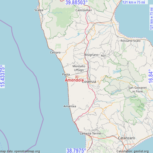
Amendola GPS coordinates[2]
39° 20' 36.168" North, 16° 8' 12.732" East
| Map corner | latitude | longitude |
|---|---|---|
| Upper-left | 39.88503°, | 15.43375° |
| Center: | 39.34338°, | 16.13687° |
| Lower-right: | 38.7975°, | 16.84° |
| Map W x H: | 120.9×120.9 km | = 75.1×75.1mi |
| max Lat: | 47.04031° ⇑91% North |
| Amendola: | 39.34338° |
| min Lat: | ⇓9% South 35.50142° |
| min Long | Amendola | max Long |
| 6.69888° | 16.13687° | 18.48682° |
| W 93.9%⇐ | ⇒6.1% E |
Elevation
Elevation of Amendola is 483 m = 1585 ft, and this is 176.3 m = 578 ft above average elevation for this country.
| Max E: |
2085 m = 6841 ft | 22.7% |
| Amendola | 483 m 1585 ft | |
| Avg. | 306.7 m = 1006 ft | |
Min E: |
-4 m = -13 ft | 77.3% |
See also: Italy elevation on elevation.city.
Geographical zone
Amendola is located in North temperate zone (between Tropic of Cancer and the Arctic Circle). Distance of this Northern Tropic circle is 1768.7 km =1099 mi to South.| Distance of | km | miles | from Amendola |
|---|---|---|---|
| North Pole | 5632.5 | 3499.9 | to North |
| Arctic Circle | 3026.6 | 1880.6 | to North |
| Tropic Cancer | 1768.7 | 1099 | to South |
| Equator | 4374.6 | 2718.2 | to South |


Nearby cities:
15 places around Amendola: (largest is in red/bold)
• Arcavacata
6.4 km =4 mi,  74°
74°
• Bucita
0.6 km =0.4 mi,  318°
318°
• Castrolibero
6.2 km =3.9 mi,  126°
126°
• Fontanesi-Santa Lucia
6.6 km =4.1 mi,  135°
135°
• Marano Marchesato
4.6 km =2.9 mi, 137°
• Marano Principato
6 km =3.7 mi,  147°
147°
• Montalto Uffugo
6.9 km =4.3 mi,  13°
13°
• Ortomatera
7 km =4.3 mi,  107°
107°
• Rende
4 km =2.5 mi, 109°
• San Fili
0.8 km =0.5 mi,  121°
121°
• San Vincenzo la Costa
2.7 km =1.7 mi,  26°
26°
• Santa Maria di Settimo
6.7 km =4.2 mi,  56°
56°
• Santo Stefano
5.4 km =3.4 mi,  85°
85°
• Serra Miceli
7 km =4.3 mi, 127°
• Surdo
5.8 km =3.6 mi, 107°
Sources, notices
• [Note1] Compared only with cities in Italy existing in our database
• [Src1] Map data: © OpenStreetMap contributors (CC-BY-SA)
• [Src2] Other city data from geonames.org with taken over terms of usage.
• [Src3] Geographical zone / Annual Mean Temperature by Robert A. Rohde @ Wikipedia
