Sant'Alfio geodata
Sant'Alfio (Sicily) is a seat of a third-order administrative division; located in Italy in Europe/Rome (GMT+2) time zone. With population of 1,512 people, there are 5089 cities with bigger population in this country. Compared to other cities in Italy, 98% of cities are located further ↑North; 88.4% of cities are located further ←West and 83.7% of cities have lower elevation than Sant'Alfio. Note1


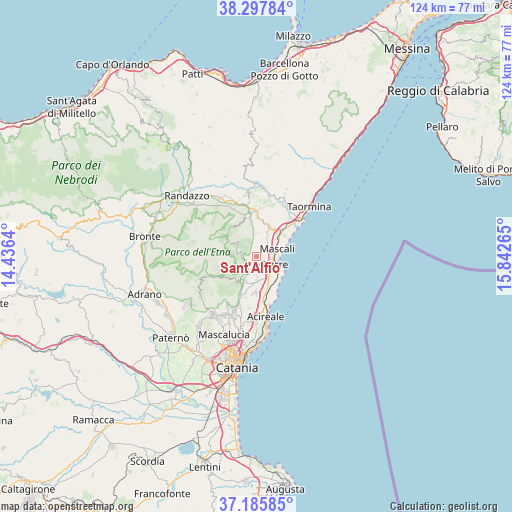
Sant'Alfio GPS coordinates[2]
37° 44' 38.148" North, 15° 8' 22.272" East
| Map corner | latitude | longitude |
|---|---|---|
| Upper-left | 38.29784°, | 14.4364° |
| Center: | 37.74393°, | 15.13952° |
| Lower-right: | 37.18585°, | 15.84265° |
| Map W x H: | 123.6×123.6 km | = 76.8×76.8mi |
| max Lat: | 47.04031° ⇑98% North |
| Sant'Alfio: | 37.74393° |
| min Lat: | ⇓2% South 35.50142° |
| min Long | Sant'Alfio | max Long |
| 6.69888° | 15.13952° | 18.48682° |
| W 88.4%⇐ | ⇒11.6% E |
Elevation
Elevation of Sant'Alfio is 586 m = 1923 ft, and this is 279.3 m = 916 ft above average elevation for this country.
| Max E: |
2085 m = 6841 ft | 16.3% |
| Sant'Alfio | 586 m 1923 ft | |
| Avg. | 306.7 m = 1006 ft | |
Min E: |
-4 m = -13 ft | 83.7% |
See also: Italy elevation on elevation.city.
Geographical zone
Sant'Alfio is located in North temperate zone (between Tropic of Cancer and the Arctic Circle). Distance of this Northern Tropic circle is 1590.8 km =988.5 mi to South.| Distance of | km | miles | from Sant'Alfio |
|---|---|---|---|
| North Pole | 5810.3 | 3610.4 | to North |
| Arctic Circle | 3204.4 | 1991.1 | to North |
| Tropic Cancer | 1590.8 | 988.5 | to South |
| Equator | 4196.7 | 2607.7 | to South |


Nearby cities:
15 places around Sant'Alfio: (largest is in red/bold)
• Carruba
7.3 km =4.5 mi,  144°
144°
• Fiumefreddo Sicilia
8.1 km =5 mi,  49°
49°
• Giarre
4.3 km =2.7 mi,  120°
120°
• Linera
8.9 km =5.5 mi,  181°
181°
• Mascali
5.3 km =3.3 mi,  72°
72°
• Milo
3 km =1.9 mi,  224°
224°
• Nunziata
3.2 km =2 mi,  59°
59°
• Pennisi
10.6 km =6.6 mi,  187°
187°
• Piedimonte Etneo
7.7 km =4.8 mi,  24°
24°
• Riposto
6 km =3.7 mi,  103°
103°
• San Giovanni
1.9 km =1.2 mi, 119°
• Sant'Anna
5.7 km =3.5 mi,  89°
89°
• Santa Venera-Portosalvo
4.8 km =3 mi,  36°
36°
• Santa Venerina
5.9 km =3.7 mi, 180°
• Zafferana Etnea
7.9 km =4.9 mi,  203°
203°
Sources, notices
• [Note1] Compared only with cities in Italy existing in our database
• [Src1] Map data: © OpenStreetMap contributors (CC-BY-SA)
• [Src2] Other city data from geonames.org with taken over terms of usage.
• [Src3] Geographical zone / Annual Mean Temperature by Robert A. Rohde @ Wikipedia
