Pennisi geodata
Pennisi (Sicily) is a populated place; located in Italy in Europe/Rome (GMT+2) time zone. With population of 1,143 people, there are 6137 cities with bigger population in this country. Compared to other cities in Italy, 98.3% of cities are located further ↑North; 88.2% of cities are located further ←West and 68.4% of cities have lower elevation than Pennisi. Note1


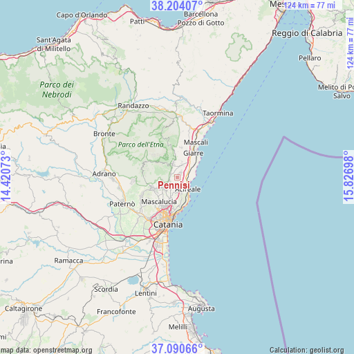
Pennisi GPS coordinates[2]
37° 38' 58.02" North, 15° 7' 25.86" East
| Map corner | latitude | longitude |
|---|---|---|
| Upper-left | 38.20407°, | 14.42073° |
| Center: | 37.64945°, | 15.12385° |
| Lower-right: | 37.09066°, | 15.82698° |
| Map W x H: | 123.8×123.8 km | = 76.9×76.9mi |
| max Lat: | 47.04031° ⇑98.3% North |
| Pennisi: | 37.64945° |
| min Lat: | ⇓1.7% South 35.50142° |
| min Long | Pennisi | max Long |
| 6.69888° | 15.12385° | 18.48682° |
| W 88.2%⇐ | ⇒11.8% E |
Elevation
Elevation of Pennisi is 377 m = 1237 ft, and this is 70.3 m = 231 ft above average elevation for this country.
| Max E: |
2085 m = 6841 ft | 31.6% |
| Pennisi | 377 m 1237 ft | |
| Avg. | 306.7 m = 1006 ft | |
Min E: |
-4 m = -13 ft | 68.4% |
See also: Italy elevation on elevation.city.
Geographical zone
Pennisi is located in North temperate zone (between Tropic of Cancer and the Arctic Circle). Distance of this Northern Tropic circle is 1580.3 km =982 mi to South.| Distance of | km | miles | from Pennisi |
|---|---|---|---|
| North Pole | 5820.8 | 3616.9 | to North |
| Arctic Circle | 3214.9 | 1997.6 | to North |
| Tropic Cancer | 1580.3 | 982 | to South |
| Equator | 4186.2 | 2601.2 | to South |


Nearby cities:
15 places around Pennisi: (largest is in red/bold)
• Aci Bonaccorsi
6.1 km =3.8 mi,  193°
193°
• Aci Catena
5.1 km =3.2 mi,  161°
161°
• Aci Sant'Antonio
4.9 km =3 mi,  180°
180°
• Acireale
5.8 km =3.6 mi,  140°
140°
• Carruba
7.3 km =4.5 mi,  51°
51°
• Lavinaio-Monterosso
1.9 km =1.2 mi,  240°
240°
• Linera
1.9 km =1.2 mi,  34°
34°
• Maugeri
7.1 km =4.4 mi, 184°
• Monterosso
3 km =1.9 mi,  255°
255°
• Pedara
6.6 km =4.1 mi, 244°
• Santa Maria la Stella
2.9 km =1.8 mi, 185°
• Santa Venerina
4.8 km =3 mi,  15°
15°
• Trecastagni
5.5 km =3.4 mi,  226°
226°
• Viagrande
4.9 km =3 mi,  207°
207°
• Zafferana Etnea
3.7 km =2.3 mi,  332°
332°
Sources, notices
• [Note1] Compared only with cities in Italy existing in our database
• [Src1] Map data: © OpenStreetMap contributors (CC-BY-SA)
• [Src2] Other city data from geonames.org with taken over terms of usage.
• [Src3] Geographical zone / Annual Mean Temperature by Robert A. Rohde @ Wikipedia
