Carruba geodata
Carruba (Sicily) is a populated place; located in Italy in Europe/Rome (GMT+2) time zone. With population of 1,099 people, there are 6299 cities with bigger population in this country. Compared to other cities in Italy, 98.1% of cities are located further ↑North; 88.7% of cities are located further ←West and 69% of cities have higher elevation than Carruba. Note1


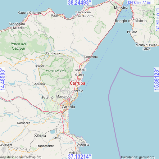
Carruba GPS coordinates[2]
37° 41' 26.232" North, 15° 11' 17.34" East
| Map corner | latitude | longitude |
|---|---|---|
| Upper-left | 38.24493°, | 14.48503° |
| Center: | 37.69062°, | 15.18815° |
| Lower-right: | 37.13214°, | 15.89128° |
| Map W x H: | 123.7×123.7 km | = 76.9×76.9mi |
| max Lat: | 47.04031° ⇑98.1% North |
| Carruba: | 37.69062° |
| min Lat: | ⇓1.9% South 35.50142° |
| min Long | Carruba | max Long |
| 6.69888° | 15.18815° | 18.48682° |
| W 88.7%⇐ | ⇒11.3% E |
Elevation
Elevation of Carruba is 103 m = 338 ft, and this is 203.7 m = 668 ft below average elevation for this country.
| Max E: |
2085 m = 6841 ft | 69% |
| Avg. | 306.7 m = 1006 ft | |
| Carruba | 103 m = 338 ft | |
Min E: |
-4 m = -13 ft | 31% |
See also: Italy elevation on elevation.city.
Geographical zone
Carruba is located in North temperate zone (between Tropic of Cancer and the Arctic Circle). Distance of this Northern Tropic circle is 1584.9 km =984.8 mi to South.| Distance of | km | miles | from Carruba |
|---|---|---|---|
| North Pole | 5816.3 | 3614.1 | to North |
| Arctic Circle | 3210.4 | 1994.8 | to North |
| Tropic Cancer | 1584.9 | 984.8 | to South |
| Equator | 4190.8 | 2604 | to South |


Nearby cities:
15 places around Carruba: (largest is in red/bold)
• Acireale
9.3 km =5.8 mi,  192°
192°
• Giarre
3.8 km =2.4 mi,  351°
351°
• Lavinaio-Monterosso
9.2 km =5.7 mi,  233°
233°
• Linera
5.4 km =3.4 mi,  236°
236°
• Mascali
7.5 km =4.7 mi,  5°
5°
• Milo
7.4 km =4.6 mi,  300°
300°
• Nunziata
7.7 km =4.8 mi, 348°
• Pennisi
7.3 km =4.5 mi, 231°
• Riposto
4.8 km =3 mi,  18°
18°
• San Giovanni
5.6 km =3.5 mi,  332°
332°
• Sant'Alfio
7.3 km =4.5 mi,  324°
324°
• Sant'Anna
6.2 km =3.9 mi, 13°
• Santa Maria la Stella
9.5 km =5.9 mi,  218°
218°
• Santa Venerina
4.3 km =2.7 mi,  270°
270°
• Zafferana Etnea
7.5 km =4.7 mi,  260°
260°
Sources, notices
• [Note1] Compared only with cities in Italy existing in our database
• [Src1] Map data: © OpenStreetMap contributors (CC-BY-SA)
• [Src2] Other city data from geonames.org with taken over terms of usage.
• [Src3] Geographical zone / Annual Mean Temperature by Robert A. Rohde @ Wikipedia
