Nurallao geodata
Nurallao (Sardinia) is a seat of a third-order administrative division; located in Italy in Europe/Rome (GMT+2) time zone. With population of 1,205 people, there are 5942 cities with bigger population in this country. Compared to other cities in Italy, 89.1% of cities are located further ↑North; 80.1% of cities are located further →East and 69.7% of cities have lower elevation than Nurallao. Note1


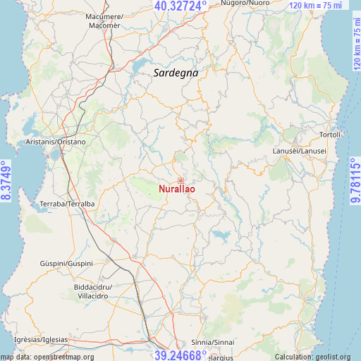
Nurallao GPS coordinates[2]
39° 47' 20.688" North, 9° 4' 40.872" East
| Map corner | latitude | longitude |
|---|---|---|
| Upper-left | 40.32724°, | 8.3749° |
| Center: | 39.78908°, | 9.07802° |
| Lower-right: | 39.24668°, | 9.78115° |
| Map W x H: | 120.1×120.1 km | = 74.6×74.6mi |
| max Lat: | 47.04031° ⇑89.1% North |
| Nurallao: | 39.78908° |
| min Lat: | ⇓10.9% South 35.50142° |
| min Long | Nurallao | max Long |
| 6.69888° | 9.07802° | 18.48682° |
| W 19.9%⇐ | ⇒80.1% E |
Elevation
Elevation of Nurallao is 391 m = 1283 ft, and this is 84.3 m = 277 ft above average elevation for this country.
| Max E: |
2085 m = 6841 ft | 30.3% |
| Nurallao | 391 m 1283 ft | |
| Avg. | 306.7 m = 1006 ft | |
Min E: |
-4 m = -13 ft | 69.7% |
See also: Italy elevation on elevation.city.
Geographical zone
Nurallao is located in North temperate zone (between Tropic of Cancer and the Arctic Circle). Distance of this Northern Tropic circle is 1818.2 km =1129.8 mi to South.| Distance of | km | miles | from Nurallao |
|---|---|---|---|
| North Pole | 5582.9 | 3469.1 | to North |
| Arctic Circle | 2977 | 1849.8 | to North |
| Tropic Cancer | 1818.2 | 1129.8 | to South |
| Equator | 4424.1 | 2749 | to South |


Nearby cities:
15 places around Nurallao: (largest is in red/bold)
• Assolo
13.7 km =8.5 mi,  279°
279°
• Barumini
11.6 km =7.2 mi,  213°
213°
• Escolca
10.7 km =6.6 mi,  159°
159°
• Genoni
6 km =3.7 mi,  274°
274°
• Gergei
10.2 km =6.3 mi,  169°
169°
• Gesturi
8 km =5 mi,  217°
217°
• Isili
6.2 km =3.9 mi,  152°
152°
• Laconi
7.5 km =4.7 mi,  342°
342°
• Nuragus
3.7 km =2.3 mi,  250°
250°
• Nureci
9.6 km =6 mi,  293°
293°
• Senis
12.5 km =7.8 mi, 287°
• Serri
11.3 km =7 mi, 149°
• Setzu
13.9 km =8.6 mi,  238°
238°
• Tuili
13 km =8.1 mi,  230°
230°
• Villanova Tulo
11.7 km =7.3 mi,  94°
94°
Sources, notices
• [Note1] Compared only with cities in Italy existing in our database
• [Src1] Map data: © OpenStreetMap contributors (CC-BY-SA)
• [Src2] Other city data from geonames.org with taken over terms of usage.
• [Src3] Geographical zone / Annual Mean Temperature by Robert A. Rohde @ Wikipedia
