Gergei geodata
Gergei (Sardinia) is a seat of a third-order administrative division; located in Italy in Europe/Rome (GMT+2) time zone. With population of 1,298 people, there are 5640 cities with bigger population in this country. Compared to other cities in Italy, 89.5% of cities are located further ↑North; 79.7% of cities are located further →East and 67.3% of cities have lower elevation than Gergei. Note1


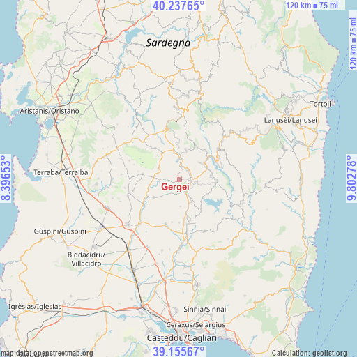
Gergei GPS coordinates[2]
39° 41' 55.608" North, 9° 5' 58.74" East
| Map corner | latitude | longitude |
|---|---|---|
| Upper-left | 40.23765°, | 8.39653° |
| Center: | 39.69878°, | 9.09965° |
| Lower-right: | 39.15567°, | 9.80278° |
| Map W x H: | 120.3×120.3 km | = 74.8×74.8mi |
| max Lat: | 47.04031° ⇑89.5% North |
| Gergei: | 39.69878° |
| min Lat: | ⇓10.5% South 35.50142° |
| min Long | Gergei | max Long |
| 6.69888° | 9.09965° | 18.48682° |
| W 20.3%⇐ | ⇒79.7% E |
Elevation
Elevation of Gergei is 366 m = 1201 ft, and this is 59.3 m = 195 ft above average elevation for this country.
| Max E: |
2085 m = 6841 ft | 32.7% |
| Gergei | 366 m 1201 ft | |
| Avg. | 306.7 m = 1006 ft | |
Min E: |
-4 m = -13 ft | 67.3% |
See also: Italy elevation on elevation.city.
Geographical zone
Gergei is located in North temperate zone (between Tropic of Cancer and the Arctic Circle). Distance of this Northern Tropic circle is 1808.2 km =1123.6 mi to South.| Distance of | km | miles | from Gergei |
|---|---|---|---|
| North Pole | 5593 | 3475.3 | to North |
| Arctic Circle | 2987.1 | 1856.1 | to North |
| Tropic Cancer | 1808.2 | 1123.6 | to South |
| Equator | 4414.1 | 2742.8 | to South |


Nearby cities:
15 places around Gergei: (largest is in red/bold)
• Barumini
8.2 km =5.1 mi,  272°
272°
• Escolca
1.9 km =1.2 mi,  90°
90°
• Genoni
13.1 km =8.1 mi,  323°
323°
• Gesico
9.2 km =5.7 mi,  176°
176°
• Gesturi
7.7 km =4.8 mi,  298°
298°
• Isili
4.6 km =2.9 mi,  12°
12°
• Las Plassas
10.1 km =6.3 mi,  257°
257°
• Mandas
5.5 km =3.4 mi,  152°
152°
• Nuragus
10.3 km =6.4 mi,  328°
328°
• Nurallao
10.2 km =6.3 mi,  349°
349°
• Nurri
11.2 km =7 mi,  82°
82°
• Orroli
12.9 km =8 mi, 93°
• Serri
3.9 km =2.4 mi, 85°
• Tuili
12.1 km =7.5 mi,  278°
278°
• Villanovafranca
10.3 km =6.4 mi,  234°
234°
Sources, notices
• [Note1] Compared only with cities in Italy existing in our database
• [Src1] Map data: © OpenStreetMap contributors (CC-BY-SA)
• [Src2] Other city data from geonames.org with taken over terms of usage.
• [Src3] Geographical zone / Annual Mean Temperature by Robert A. Rohde @ Wikipedia
