Nureci geodata
Nureci (Sardinia) is a seat of a third-order administrative division; located in Italy in Europe/Rome (GMT+2) time zone. With population of 318 people, there are 10601 cities with bigger population in this country. Compared to other cities in Italy, 88.9% of cities are located further ↑North; 81.6% of cities are located further →East and 64.8% of cities have lower elevation than Nureci. Note1


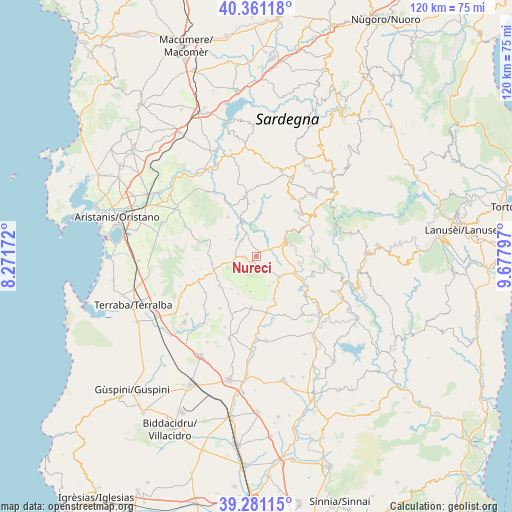
Nureci GPS coordinates[2]
39° 49' 23.844" North, 8° 58' 29.424" East
| Map corner | latitude | longitude |
|---|---|---|
| Upper-left | 40.36118°, | 8.27172° |
| Center: | 39.82329°, | 8.97484° |
| Lower-right: | 39.28115°, | 9.67797° |
| Map W x H: | 120.1×120.1 km | = 74.6×74.6mi |
| max Lat: | 47.04031° ⇑88.9% North |
| Nureci: | 39.82329° |
| min Lat: | ⇓11.1% South 35.50142° |
| min Long | Nureci | max Long |
| 6.69888° | 8.97484° | 18.48682° |
| W 18.4%⇐ | ⇒81.6% E |
Elevation
Elevation of Nureci is 341 m = 1119 ft, and this is 34.3 m = 113 ft above average elevation for this country.
| Max E: |
2085 m = 6841 ft | 35.2% |
| Nureci | 341 m 1119 ft | |
| Avg. | 306.7 m = 1006 ft | |
Min E: |
-4 m = -13 ft | 64.8% |
See also: Italy elevation on elevation.city.
Geographical zone
Nureci is located in North temperate zone (between Tropic of Cancer and the Arctic Circle). Distance of this Northern Tropic circle is 1822 km =1132.1 mi to South.| Distance of | km | miles | from Nureci |
|---|---|---|---|
| North Pole | 5579.1 | 3466.7 | to North |
| Arctic Circle | 2973.2 | 1847.5 | to North |
| Tropic Cancer | 1822 | 1132.1 | to South |
| Equator | 4427.9 | 2751.4 | to South |


Nearby cities:
15 places around Nureci: (largest is in red/bold)
• Albagiara
10.5 km =6.5 mi,  247°
247°
• Assolo
5 km =3.1 mi, 251°
• Asuni
5.8 km =3.6 mi,  335°
335°
• Genoni
4.3 km =2.7 mi,  139°
139°
• Genuri
9.9 km =6.2 mi,  205°
205°
• Gesturi
10.8 km =6.7 mi,  158°
158°
• Gonnosnò
11.2 km =7 mi,  231°
231°
• Laconi
7.4 km =4.6 mi,  63°
63°
• Mogorella
10.9 km =6.8 mi,  294°
294°
• Nuragus
7.4 km =4.6 mi,  133°
133°
• Nurallao
9.6 km =6 mi,  113°
113°
• Senis
3 km =1.9 mi,  269°
269°
• Sini
9.8 km =6.1 mi,  217°
217°
• Usellus
10.7 km =6.6 mi,  261°
261°
• Villa Sant'Antonio
7.4 km =4.6 mi,  302°
302°
Sources, notices
• [Note1] Compared only with cities in Italy existing in our database
• [Src1] Map data: © OpenStreetMap contributors (CC-BY-SA)
• [Src2] Other city data from geonames.org with taken over terms of usage.
• [Src3] Geographical zone / Annual Mean Temperature by Robert A. Rohde @ Wikipedia
