Gesturi geodata
Gesturi (Sardinia) is a seat of a third-order administrative division; located in Italy in Europe/Rome (GMT+2) time zone. With population of 1,226 people, there are 5882 cities with bigger population in this country. Compared to other cities in Italy, 89.3% of cities are located further ↑North; 81% of cities are located further →East and 61.5% of cities have lower elevation than Gesturi. Note1


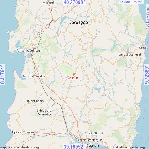
Gesturi GPS coordinates[2]
39° 43' 56.532" North, 9° 1' 14.772" East
| Map corner | latitude | longitude |
|---|---|---|
| Upper-left | 40.27098°, | 8.31764° |
| Center: | 39.73237°, | 9.02077° |
| Lower-right: | 39.18952°, | 9.72389° |
| Map W x H: | 120.2×120.2 km | = 74.7×74.7mi |
| max Lat: | 47.04031° ⇑89.3% North |
| Gesturi: | 39.73237° |
| min Lat: | ⇓10.7% South 35.50142° |
| min Long | Gesturi | max Long |
| 6.69888° | 9.02077° | 18.48682° |
| W 19%⇐ | ⇒81% E |
Elevation
Elevation of Gesturi is 311 m = 1020 ft, and this is 4.3 m = 14 ft above average elevation for this country.
| Max E: |
2085 m = 6841 ft | 38.5% |
| Gesturi | 311 m 1020 ft | |
| Avg. | 306.7 m = 1006 ft | |
Min E: |
-4 m = -13 ft | 61.5% |
See also: Italy elevation on elevation.city.
Geographical zone
Gesturi is located in North temperate zone (between Tropic of Cancer and the Arctic Circle). Distance of this Northern Tropic circle is 1811.9 km =1125.9 mi to South.| Distance of | km | miles | from Gesturi |
|---|---|---|---|
| North Pole | 5589.2 | 3473 | to North |
| Arctic Circle | 2983.3 | 1853.7 | to North |
| Tropic Cancer | 1811.9 | 1125.9 | to South |
| Equator | 4417.8 | 2745.1 | to South |


Nearby cities:
15 places around Gesturi: (largest is in red/bold)
• Barumini
3.7 km =2.3 mi,  203°
203°
• Escolca
9.4 km =5.8 mi,  113°
113°
• Genoni
6.9 km =4.3 mi,  350°
350°
• Genuri
8.4 km =5.2 mi,  278°
278°
• Gergei
7.7 km =4.8 mi,  118°
118°
• Isili
7.8 km =4.8 mi,  84°
84°
• Las Plassas
6.6 km =4.1 mi,  208°
208°
• Nuragus
5.2 km =3.2 mi,  15°
15°
• Nurallao
8 km =5 mi,  37°
37°
• Setzu
7 km =4.3 mi,  261°
261°
• Sini
10.2 km =6.3 mi, 283°
• Tuili
5.5 km =3.4 mi,  249°
249°
• Turri
9.4 km =5.8 mi, 250°
• Ussaramanna
10.6 km =6.6 mi, 245°
• Villanovafranca
9.9 km =6.2 mi,  189°
189°
Sources, notices
• [Note1] Compared only with cities in Italy existing in our database
• [Src1] Map data: © OpenStreetMap contributors (CC-BY-SA)
• [Src2] Other city data from geonames.org with taken over terms of usage.
• [Src3] Geographical zone / Annual Mean Temperature by Robert A. Rohde @ Wikipedia
