Mormanno geodata
Mormanno (Calabria) is a seat of a third-order administrative division; located in Italy in Europe/Rome (GMT+2) time zone. With population of 2,771 people, there are 3243 cities with bigger population in this country. Compared to other cities in Italy, 88.6% of cities are located further ↑North; 92.8% of cities are located further ←West and 92.2% of cities have lower elevation than Mormanno. Note1


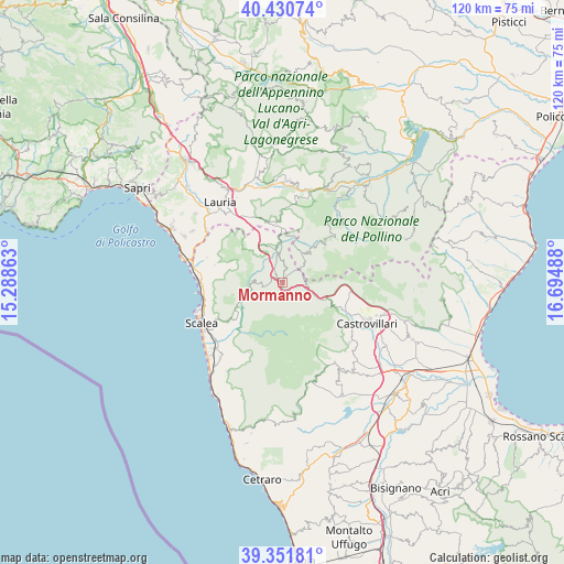
Mormanno GPS coordinates[2]
39° 53' 36.24" North, 15° 59' 30.3" East
| Map corner | latitude | longitude |
|---|---|---|
| Upper-left | 40.43074°, | 15.28863° |
| Center: | 39.8934°, | 15.99175° |
| Lower-right: | 39.35181°, | 16.69488° |
| Map W x H: | 120×120 km | = 74.6×74.6mi |
| max Lat: | 47.04031° ⇑88.6% North |
| Mormanno: | 39.8934° |
| min Lat: | ⇓11.4% South 35.50142° |
| min Long | Mormanno | max Long |
| 6.69888° | 15.99175° | 18.48682° |
| W 92.8%⇐ | ⇒7.2% E |
Elevation
Elevation of Mormanno is 778 m = 2552 ft, and this is 471.3 m = 1546 ft above average elevation for this country.
| Max E: |
2085 m = 6841 ft | 7.8% |
| Mormanno | 778 m 2552 ft | |
| Avg. | 306.7 m = 1006 ft | |
Min E: |
-4 m = -13 ft | 92.2% |
See also: Italy elevation on elevation.city.
Geographical zone
Mormanno is located in North temperate zone (between Tropic of Cancer and the Arctic Circle). Distance of this Northern Tropic circle is 1829.8 km =1137 mi to South.| Distance of | km | miles | from Mormanno |
|---|---|---|---|
| North Pole | 5571.3 | 3461.8 | to North |
| Arctic Circle | 2965.4 | 1842.6 | to North |
| Tropic Cancer | 1829.8 | 1137 | to South |
| Equator | 4435.7 | 2756.2 | to South |


Nearby cities:
15 places around Mormanno: (largest is in red/bold)
• Aieta
14.9 km =9.3 mi,  284°
284°
• Castelluccio Inferiore
12.1 km =7.5 mi,  355°
355°
• Castelluccio Superiore
13.1 km =8.1 mi,  352°
352°
• Laino Borgo
6.9 km =4.3 mi, 347°
• Laino Castello-Nuovo Centro
4.9 km =3 mi,  344°
344°
• Morano Calabro
13.8 km =8.6 mi,  114°
114°
• Orsomarso
12.7 km =7.9 mi,  214°
214°
• Papasidero
7.7 km =4.8 mi,  251°
251°
• Pedali
12.7 km =7.9 mi,  27°
27°
• Rotonda
7.7 km =4.8 mi, 31°
• San Basile
17.4 km =10.8 mi,  122°
122°
• Santa Domenica Talao
14.4 km =8.9 mi,  234°
234°
• Tortora
16.8 km =10.4 mi,  288°
288°
• Verbicaro
16.4 km =10.2 mi, 206°
• Viggianello
11.8 km =7.3 mi,  42°
42°
Sources, notices
• [Note1] Compared only with cities in Italy existing in our database
• [Src1] Map data: © OpenStreetMap contributors (CC-BY-SA)
• [Src2] Other city data from geonames.org with taken over terms of usage.
• [Src3] Geographical zone / Annual Mean Temperature by Robert A. Rohde @ Wikipedia
