Castelluccio Inferiore geodata
Castelluccio Inferiore (Basilicate) is a seat of a third-order administrative division; located in Italy in Europe/Rome (GMT+2) time zone. With population of 1,896 people, there are 4323 cities with bigger population in this country. Compared to other cities in Italy, 87.9% of cities are located further ↑North; 92.7% of cities are located further ←West and 75.6% of cities have lower elevation than Castelluccio Inferiore. Note1
Administrative division(s):
- Level 1: Basilicate
- Level 2: Provincia di Potenza
- Level 3: Castelluccio Inferiore
Current local time in Castelluccio Inferiore:
11:09 PM, WednesdayDifference from your time zone: hours


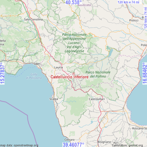
Castelluccio Inferiore GPS coordinates[2]
40° 0' 5.436" North, 15° 58' 53.364" East
| Map corner | latitude | longitude |
|---|---|---|
| Upper-left | 40.538°, | 15.27837° |
| Center: | 40.00151°, | 15.98149° |
| Lower-right: | 39.46077°, | 16.68462° |
| Map W x H: | 119.8×119.8 km | = 74.4×74.4mi |
| max Lat: | 47.04031° ⇑87.9% North |
| Castelluccio Inferiore: | 40.00151° |
| min Lat: | ⇓12.1% South 35.50142° |
| min Long | Castelluccio In | max Long |
| 6.69888° | 15.98149° | 18.48682° |
| W 92.7%⇐ | ⇒7.3% E |
Elevation
Elevation of Castelluccio Inferiore is 460 m = 1509 ft, and this is 153.3 m = 503 ft above average elevation for this country.
| Max E: |
2085 m = 6841 ft | 24.4% |
| Castelluccio Inferiore | 460 m 1509 ft | |
| Avg. | 306.7 m = 1006 ft | |
Min E: |
-4 m = -13 ft | 75.6% |
See also: Italy elevation on elevation.city.
Geographical zone
Castelluccio Inferiore is located in North temperate zone (between Tropic of Cancer and the Arctic Circle). Distance of this Northern Tropic circle is 1841.8 km =1144.4 mi to South.| Distance of | km | miles | from Castelluccio Inferiore |
|---|---|---|---|
| North Pole | 5559.3 | 3454.4 | to North |
| Arctic Circle | 2953.4 | 1835.2 | to North |
| Tropic Cancer | 1841.8 | 1144.4 | to South |
| Equator | 4447.8 | 2763.7 | to South |


Nearby cities:
15 places around Castelluccio Inferiore: (largest is in red/bold)
• Aieta
15.8 km =9.8 mi,  238°
238°
• Castelluccio Superiore
1.3 km =0.8 mi,  319°
319°
• Episcopia
12.8 km =8 mi,  50°
50°
• Laino Borgo
5.3 km =3.3 mi,  187°
187°
• Laino Castello-Nuovo Centro
7.3 km =4.5 mi,  183°
183°
• Latronico
10 km =6.2 mi,  13°
13°
• Lauria
13.2 km =8.2 mi,  292°
292°
• Magnano
8.6 km =5.3 mi, 46°
• Mormanno
12.1 km =7.5 mi, 175°
• Papasidero
15.8 km =9.8 mi,  204°
204°
• Pedali
6.8 km =4.2 mi,  95°
95°
• Rotonda
7.4 km =4.6 mi,  138°
138°
• S.Maria Fiumicello
12.3 km =7.6 mi, 286°
• San Severino Lucano
13.5 km =8.4 mi,  81°
81°
• Viggianello
9.4 km =5.8 mi,  110°
110°
Sources, notices
• [Note1] Compared only with cities in Italy existing in our database
• [Src1] Map data: © OpenStreetMap contributors (CC-BY-SA)
• [Src2] Other city data from geonames.org with taken over terms of usage.
• [Src3] Geographical zone / Annual Mean Temperature by Robert A. Rohde @ Wikipedia
