Rotonda geodata
Rotonda (Basilicate) is a seat of a third-order administrative division; located in Italy in Europe/Rome (GMT+2) time zone. With population of 1,699 people, there are 4668 cities with bigger population in this country. Compared to other cities in Italy, 88.3% of cities are located further ↑North; 93% of cities are located further ←West and 83.5% of cities have lower elevation than Rotonda. Note1


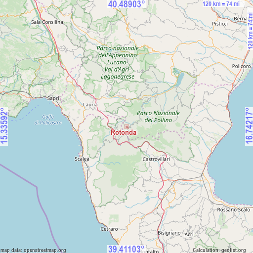
Rotonda GPS coordinates[2]
39° 57' 7.74" North, 16° 2' 20.544" East
| Map corner | latitude | longitude |
|---|---|---|
| Upper-left | 40.48903°, | 15.33592° |
| Center: | 39.95215°, | 16.03904° |
| Lower-right: | 39.41103°, | 16.74217° |
| Map W x H: | 119.9×119.9 km | = 74.5×74.5mi |
| max Lat: | 47.04031° ⇑88.3% North |
| Rotonda: | 39.95215° |
| min Lat: | ⇓11.7% South 35.50142° |
| min Long | Rotonda | max Long |
| 6.69888° | 16.03904° | 18.48682° |
| W 93%⇐ | ⇒7% E |
Elevation
Elevation of Rotonda is 580 m = 1903 ft, and this is 273.3 m = 897 ft above average elevation for this country.
| Max E: |
2085 m = 6841 ft | 16.5% |
| Rotonda | 580 m 1903 ft | |
| Avg. | 306.7 m = 1006 ft | |
Min E: |
-4 m = -13 ft | 83.5% |
See also: Italy elevation on elevation.city.
Geographical zone
Rotonda is located in North temperate zone (between Tropic of Cancer and the Arctic Circle). Distance of this Northern Tropic circle is 1836.3 km =1141 mi to South.| Distance of | km | miles | from Rotonda |
|---|---|---|---|
| North Pole | 5564.8 | 3457.8 | to North |
| Arctic Circle | 2958.9 | 1838.6 | to North |
| Tropic Cancer | 1836.3 | 1141 | to South |
| Equator | 4442.3 | 2760.3 | to South |


Nearby cities:
15 places around Rotonda: (largest is in red/bold)
• Aieta
18.6 km =11.6 mi,  261°
261°
• Castelluccio Inferiore
7.4 km =4.6 mi,  318°
318°
• Castelluccio Superiore
8.6 km =5.3 mi, 318°
• Episcopia
14.5 km =9 mi,  20°
20°
• Laino Borgo
5.6 km =3.5 mi,  272°
272°
• Laino Castello-Nuovo Centro
5.6 km =3.5 mi,  251°
251°
• Latronico
15.4 km =9.6 mi,  350°
350°
• Magnano
11.5 km =7.1 mi,  6°
6°
• Morano Calabro
14.9 km =9.3 mi,  145°
145°
• Mormanno
7.7 km =4.8 mi,  211°
211°
• Papasidero
14.5 km =9 mi,  231°
231°
• Pedali
5.1 km =3.2 mi, 20°
• S.Maria Fiumicello
19 km =11.8 mi,  297°
297°
• San Severino Lucano
11.4 km =7.1 mi,  48°
48°
• Viggianello
4.5 km =2.8 mi,  60°
60°
Sources, notices
• [Note1] Compared only with cities in Italy existing in our database
• [Src1] Map data: © OpenStreetMap contributors (CC-BY-SA)
• [Src2] Other city data from geonames.org with taken over terms of usage.
• [Src3] Geographical zone / Annual Mean Temperature by Robert A. Rohde @ Wikipedia
