Maida geodata
Maida (Calabria) is a seat of a third-order administrative division; located in Italy in Europe/Rome (GMT+2) time zone. With population of 2,766 people, there are 3248 cities with bigger population in this country. Compared to other cities in Italy, 93.1% of cities are located further ↑North; 95.7% of cities are located further ←West and 53.4% of cities have lower elevation than Maida. Note1


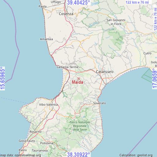
Maida GPS coordinates[2]
38° 51' 31.824" North, 16° 21' 45.972" East
| Map corner | latitude | longitude |
|---|---|---|
| Upper-left | 39.40425°, | 15.65965° |
| Center: | 38.85884°, | 16.36277° |
| Lower-right: | 38.30922°, | 17.0659° |
| Map W x H: | 121.8×121.8 km | = 75.7×75.7mi |
| max Lat: | 47.04031° ⇑93.1% North |
| Maida: | 38.85884° |
| min Lat: | ⇓6.9% South 35.50142° |
| min Long | Maida | max Long |
| 6.69888° | 16.36277° | 18.48682° |
| W 95.7%⇐ | ⇒4.3% E |
Elevation
Elevation of Maida is 255 m = 837 ft, and this is 51.7 m = 170 ft below average elevation for this country.
| Max E: |
2085 m = 6841 ft | 46.6% |
| Avg. | 306.7 m = 1006 ft | |
| Maida | 255 m = 837 ft | |
Min E: |
-4 m = -13 ft | 53.4% |
See also: Italy elevation on elevation.city.
Geographical zone
Maida is located in North temperate zone (between Tropic of Cancer and the Arctic Circle). Distance of this Northern Tropic circle is 1714.8 km =1065.5 mi to South.| Distance of | km | miles | from Maida |
|---|---|---|---|
| North Pole | 5686.4 | 3533.4 | to North |
| Arctic Circle | 3080.5 | 1914.1 | to North |
| Tropic Cancer | 1714.8 | 1065.5 | to South |
| Equator | 4320.7 | 2684.8 | to South |


Nearby cities:
15 places around Maida: (largest is in red/bold)
• Acconia
8.8 km =5.5 mi,  253°
253°
• Amaroni
10.3 km =6.4 mi,  134°
134°
• Cancello
10.8 km =6.7 mi,  32°
32°
• Caraffa di Catanzaro
11 km =6.8 mi,  76°
76°
• Cortale
4.6 km =2.9 mi,  117°
117°
• Curinga
5.5 km =3.4 mi,  231°
231°
• Feroleto Antico
11.7 km =7.3 mi,  10°
10°
• Filadelfia
10.3 km =6.4 mi,  216°
216°
• Francavilla Angitola
11.7 km =7.3 mi, 221°
• Girifalco
6.6 km =4.1 mi, 123°
• Jacurso
2 km =1.2 mi, 132°
• Pianopoli
10.6 km =6.6 mi, 12°
• San Pietro a Maida
2.3 km =1.4 mi,  235°
235°
• Santa Eufemia Lamezia
11.7 km =7.3 mi,  305°
305°
• Vena di Maida
5.1 km =3.2 mi,  51°
51°
Sources, notices
• [Note1] Compared only with cities in Italy existing in our database
• [Src1] Map data: © OpenStreetMap contributors (CC-BY-SA)
• [Src2] Other city data from geonames.org with taken over terms of usage.
• [Src3] Geographical zone / Annual Mean Temperature by Robert A. Rohde @ Wikipedia
