Curinga geodata
Curinga (Calabria) is a populated place; located in Italy in Europe/Rome (GMT+2) time zone. With population of 2,590 people, there are 3424 cities with bigger population in this country. Compared to other cities in Italy, 93.1% of cities are located further ↑North; 95.3% of cities are located further ←West and 73.6% of cities have lower elevation than Curinga. Note1


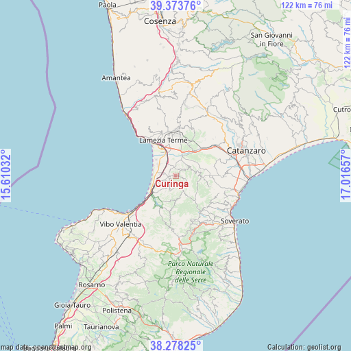
Curinga GPS coordinates[2]
38° 49' 41.196" North, 16° 18' 48.384" East
| Map corner | latitude | longitude |
|---|---|---|
| Upper-left | 39.37376°, | 15.61032° |
| Center: | 38.82811°, | 16.31344° |
| Lower-right: | 38.27825°, | 17.01657° |
| Map W x H: | 121.8×121.8 km | = 75.7×75.7mi |
| max Lat: | 47.04031° ⇑93.1% North |
| Curinga: | 38.82811° |
| min Lat: | ⇓6.9% South 35.50142° |
| min Long | Curinga | max Long |
| 6.69888° | 16.31344° | 18.48682° |
| W 95.3%⇐ | ⇒4.7% E |
Elevation
Elevation of Curinga is 433 m = 1421 ft, and this is 126.3 m = 414 ft above average elevation for this country.
| Max E: |
2085 m = 6841 ft | 26.4% |
| Curinga | 433 m 1421 ft | |
| Avg. | 306.7 m = 1006 ft | |
Min E: |
-4 m = -13 ft | 73.6% |
See also: Italy elevation on elevation.city.
Geographical zone
Curinga is located in North temperate zone (between Tropic of Cancer and the Arctic Circle). Distance of this Northern Tropic circle is 1711.4 km =1063.4 mi to South.| Distance of | km | miles | from Curinga |
|---|---|---|---|
| North Pole | 5689.8 | 3535.5 | to North |
| Arctic Circle | 3083.9 | 1916.2 | to North |
| Tropic Cancer | 1711.4 | 1063.4 | to South |
| Equator | 4317.3 | 2682.6 | to South |


Nearby cities:
15 places around Curinga: (largest is in red/bold)
• Acconia
4.3 km =2.7 mi,  281°
281°
• Amaroni
12.3 km =7.6 mi,  107°
107°
• Contrada Difesa II
8.9 km =5.5 mi,  247°
247°
• Cortale
8.4 km =5.2 mi,  80°
80°
• Filadelfia
5.2 km =3.2 mi,  201°
201°
• Francavilla Angitola
6.4 km =4 mi,  213°
213°
• Girifalco
9.8 km =6.1 mi,  91°
91°
• Jacurso
6.1 km =3.8 mi,  70°
70°
• Maida
5.5 km =3.4 mi,  51°
51°
• Marinella
13.4 km =8.3 mi,  324°
324°
• Monterosso Calabro
12.5 km =7.8 mi,  189°
189°
• Polia
8.6 km =5.3 mi,  180°
180°
• San Pietro a Maida
3.2 km =2 mi, 48°
• Santa Eufemia Lamezia
11.5 km =7.1 mi,  332°
332°
• Vena di Maida
10.6 km =6.6 mi, 51°
Sources, notices
• [Note1] Compared only with cities in Italy existing in our database
• [Src1] Map data: © OpenStreetMap contributors (CC-BY-SA)
• [Src2] Other city data from geonames.org with taken over terms of usage.
• [Src3] Geographical zone / Annual Mean Temperature by Robert A. Rohde @ Wikipedia
