Girifalco geodata
Girifalco (Calabria) is a seat of a third-order administrative division; located in Italy in Europe/Rome (GMT+2) time zone. With population of 5,874 people, there are 1671 cities with bigger population in this country. Compared to other cities in Italy, 93.1% of cities are located further ↑North; 95.9% of cities are located further ←West and 75.1% of cities have lower elevation than Girifalco. Note1


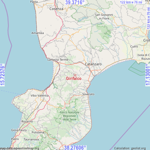
Girifalco GPS coordinates[2]
38° 49' 33.384" North, 16° 25' 36.768" East
| Map corner | latitude | longitude |
|---|---|---|
| Upper-left | 39.3716°, | 15.72376° |
| Center: | 38.82594°, | 16.42688° |
| Lower-right: | 38.27606°, | 17.13001° |
| Map W x H: | 121.8×121.8 km | = 75.7×75.7mi |
| max Lat: | 47.04031° ⇑93.1% North |
| Girifalco: | 38.82594° |
| min Lat: | ⇓6.9% South 35.50142° |
| min Long | Girifalco | max Long |
| 6.69888° | 16.42688° | 18.48682° |
| W 95.9%⇐ | ⇒4.1% E |
Elevation
Elevation of Girifalco is 453 m = 1486 ft, and this is 146.3 m = 480 ft above average elevation for this country.
| Max E: |
2085 m = 6841 ft | 24.9% |
| Girifalco | 453 m 1486 ft | |
| Avg. | 306.7 m = 1006 ft | |
Min E: |
-4 m = -13 ft | 75.1% |
See also: Italy elevation on elevation.city.
Geographical zone
Girifalco is located in North temperate zone (between Tropic of Cancer and the Arctic Circle). Distance of this Northern Tropic circle is 1711.1 km =1063.2 mi to South.| Distance of | km | miles | from Girifalco |
|---|---|---|---|
| North Pole | 5690 | 3535.6 | to North |
| Arctic Circle | 3084.1 | 1916.4 | to North |
| Tropic Cancer | 1711.1 | 1063.2 | to South |
| Equator | 4317 | 2682.5 | to South |


Nearby cities:
15 places around Girifalco: (largest is in red/bold)
• Amaroni
4 km =2.5 mi,  152°
152°
• Borgia
7 km =4.3 mi,  89°
89°
• Caraffa di Catanzaro
8.1 km =5 mi,  39°
39°
• Centrache
10.8 km =6.7 mi,  178°
178°
• Cortale
2.2 km =1.4 mi,  316°
316°
• Curinga
9.8 km =6.1 mi,  271°
271°
• Jacurso
4.7 km =2.9 mi,  299°
299°
• Maida
6.6 km =4.1 mi, 303°
• Olivadi
11.2 km =7 mi, 181°
• Palermiti
8.9 km =5.5 mi,  165°
165°
• San Floro
8.1 km =5 mi,  80°
80°
• San Pietro a Maida
7.8 km =4.8 mi,  287°
287°
• Squillace
8.9 km =5.5 mi,  124°
124°
• Vallefiorita
6.3 km =3.9 mi, 151°
• Vena di Maida
7 km =4.3 mi,  347°
347°
Sources, notices
• [Note1] Compared only with cities in Italy existing in our database
• [Src1] Map data: © OpenStreetMap contributors (CC-BY-SA)
• [Src2] Other city data from geonames.org with taken over terms of usage.
• [Src3] Geographical zone / Annual Mean Temperature by Robert A. Rohde @ Wikipedia
