Giba geodata
Giba (Sardinia) is a seat of a third-order administrative division; located in Italy in Europe/Rome (GMT+2) time zone. With population of 1,559 people, there are 4981 cities with bigger population in this country. Compared to other cities in Italy, 92.4% of cities are located further ↑North; 86.3% of cities are located further →East and 77% of cities have higher elevation than Giba. Note1


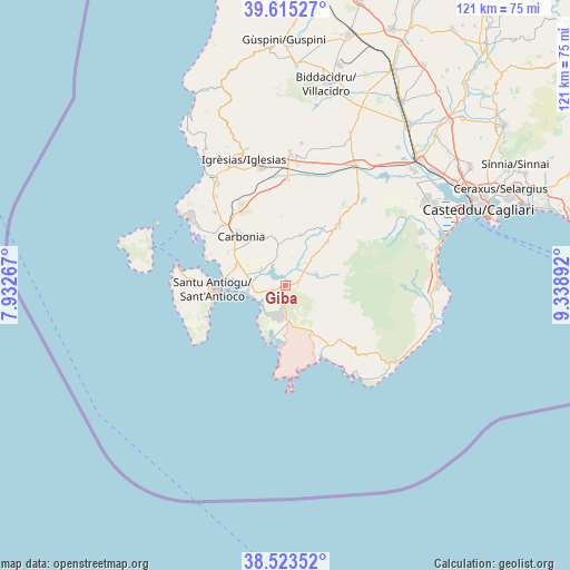
Giba GPS coordinates[2]
39° 4' 17.436" North, 8° 38' 8.88" East
| Map corner | latitude | longitude |
|---|---|---|
| Upper-left | 39.61527°, | 7.93267° |
| Center: | 39.07151°, | 8.6358° |
| Lower-right: | 38.52352°, | 9.33892° |
| Map W x H: | 121.4×121.4 km | = 75.4×75.4mi |
| max Lat: | 47.04031° ⇑92.4% North |
| Giba: | 39.07151° |
| min Lat: | ⇓7.6% South 35.50142° |
| min Long | Giba | max Long |
| 6.69888° | 8.6358° | 18.48682° |
| W 13.7%⇐ | ⇒86.3% E |
Elevation
Elevation of Giba is 64 m = 210 ft, and this is 242.7 m = 796 ft below average elevation for this country.
| Max E: |
2085 m = 6841 ft | 77% |
| Avg. | 306.7 m = 1006 ft | |
| Giba | 64 m = 210 ft | |
Min E: |
-4 m = -13 ft | 23% |
See also: Italy elevation on elevation.city.
Geographical zone
Giba is located in North temperate zone (between Tropic of Cancer and the Arctic Circle). Distance of this Northern Tropic circle is 1738.4 km =1080.2 mi to South.| Distance of | km | miles | from Giba |
|---|---|---|---|
| North Pole | 5662.7 | 3518.6 | to North |
| Arctic Circle | 3056.8 | 1899.4 | to North |
| Tropic Cancer | 1738.4 | 1080.2 | to South |
| Equator | 4344.3 | 2699.4 | to South |


Nearby cities:
15 places around Giba: (largest is in red/bold)
• Carbonia
14.3 km =8.9 mi,  316°
316°
• Is Urigus
14.1 km =8.8 mi,  300°
300°
• Masainas
2.5 km =1.6 mi,  193°
193°
• Narcao
11.2 km =7 mi,  17°
17°
• Nuxis
12.9 km =8 mi,  44°
44°
• Perdaxius
10.1 km =6.3 mi,  347°
347°
• Piscinas
2.7 km =1.7 mi,  83°
83°
• Riomurtas
13.5 km =8.4 mi,  26°
26°
• San Giovanni Suergiu
10.8 km =6.7 mi,  293°
293°
• Sant'Anna Arresi
7.3 km =4.5 mi,  175°
175°
• Sant'Antioco
15.8 km =9.8 mi,  269°
269°
• Santadi
7.1 km =4.4 mi,  69°
69°
• Teulada
16.5 km =10.3 mi,  134°
134°
• Tratalias
6.1 km =3.8 mi,  305°
305°
• Villaperuccio
5.4 km =3.4 mi, 33°
Sources, notices
• [Note1] Compared only with cities in Italy existing in our database
• [Src1] Map data: © OpenStreetMap contributors (CC-BY-SA)
• [Src2] Other city data from geonames.org with taken over terms of usage.
• [Src3] Geographical zone / Annual Mean Temperature by Robert A. Rohde @ Wikipedia
