Nurri geodata
Nurri (Sardinia) is a seat of a third-order administrative division; located in Italy in Europe/Rome (GMT+2) time zone. With population of 2,109 people, there are 3971 cities with bigger population in this country. Compared to other cities in Italy, 89.4% of cities are located further ↑North; 77.6% of cities are located further →East and 84.4% of cities have lower elevation than Nurri. Note1


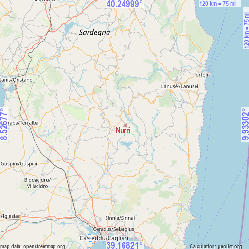
Nurri GPS coordinates[2]
39° 42' 40.392" North, 9° 13' 47.64" East
| Map corner | latitude | longitude |
|---|---|---|
| Upper-left | 40.24999°, | 8.52677° |
| Center: | 39.71122°, | 9.2299° |
| Lower-right: | 39.16821°, | 9.93302° |
| Map W x H: | 120.3×120.3 km | = 74.8×74.8mi |
| max Lat: | 47.04031° ⇑89.4% North |
| Nurri: | 39.71122° |
| min Lat: | ⇓10.6% South 35.50142° |
| min Long | Nurri | max Long |
| 6.69888° | 9.2299° | 18.48682° |
| W 22.4%⇐ | ⇒77.6% E |
Elevation
Elevation of Nurri is 598 m = 1962 ft, and this is 291.3 m = 956 ft above average elevation for this country.
| Max E: |
2085 m = 6841 ft | 15.6% |
| Nurri | 598 m 1962 ft | |
| Avg. | 306.7 m = 1006 ft | |
Min E: |
-4 m = -13 ft | 84.4% |
See also: Italy elevation on elevation.city.
Geographical zone
Nurri is located in North temperate zone (between Tropic of Cancer and the Arctic Circle). Distance of this Northern Tropic circle is 1809.6 km =1124.4 mi to South.| Distance of | km | miles | from Nurri |
|---|---|---|---|
| North Pole | 5591.6 | 3474.5 | to North |
| Arctic Circle | 2985.7 | 1855.2 | to North |
| Tropic Cancer | 1809.6 | 1124.4 | to South |
| Equator | 4415.5 | 2743.7 | to South |


Nearby cities:
15 places around Nurri: (largest is in red/bold)
• Escalaplano
14.2 km =8.8 mi,  131°
131°
• Escolca
9.4 km =5.8 mi,  261°
261°
• Esterzili
9 km =5.6 mi,  30°
30°
• Gergei
11.2 km =7 mi, 262°
• Gesico
14.9 km =9.3 mi,  225°
225°
• Goni
15.4 km =9.6 mi,  162°
162°
• Isili
10.6 km =6.6 mi,  287°
287°
• Mandas
10.6 km =6.6 mi, 234°
• Nurallao
15.6 km =9.7 mi,  303°
303°
• Orroli
2.7 km =1.7 mi,  140°
140°
• Sadali
12.1 km =7.5 mi,  17°
17°
• Serri
7.4 km =4.6 mi, 261°
• Seui
16.3 km =10.1 mi, 29°
• Siurgus Donigala
12.9 km =8 mi,  196°
196°
• Villanova Tulo
7.8 km =4.8 mi,  350°
350°
Sources, notices
• [Note1] Compared only with cities in Italy existing in our database
• [Src1] Map data: © OpenStreetMap contributors (CC-BY-SA)
• [Src2] Other city data from geonames.org with taken over terms of usage.
• [Src3] Geographical zone / Annual Mean Temperature by Robert A. Rohde @ Wikipedia
