Castro geodata
Castro (Apulia) is a seat of a third-order administrative division; located in Italy in Europe/Rome (GMT+2) time zone. With population of 1,801 people, there are 4490 cities with bigger population in this country. Compared to other cities in Italy, 87.9% of cities are located further ↑North; 99.9% of cities are located further ←West and 72% of cities have higher elevation than Castro. Note1


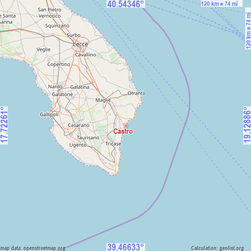
Castro GPS coordinates[2]
40° 0' 25.272" North, 18° 25' 32.628" East
| Map corner | latitude | longitude |
|---|---|---|
| Upper-left | 40.54346°, | 17.72261° |
| Center: | 40.00702°, | 18.42573° |
| Lower-right: | 39.46633°, | 19.12886° |
| Map W x H: | 119.8×119.8 km | = 74.4×74.4mi |
| max Lat: | 47.04031° ⇑87.9% North |
| Castro: | 40.00702° |
| min Lat: | ⇓12.1% South 35.50142° |
| min Long | Castro | max Long |
| 6.69888° | 18.42573° | 18.48682° |
| W 99.9%⇐ | ⇒0.099999999999994% E |
Elevation
Elevation of Castro is 88 m = 289 ft, and this is 218.7 m = 718 ft below average elevation for this country.
| Max E: |
2085 m = 6841 ft | 72% |
| Avg. | 306.7 m = 1006 ft | |
| Castro | 88 m = 289 ft | |
Min E: |
-4 m = -13 ft | 28% |
See also: Italy elevation on elevation.city.
Geographical zone
Castro is located in North temperate zone (between Tropic of Cancer and the Arctic Circle). Distance of this Northern Tropic circle is 1842.4 km =1144.8 mi to South.| Distance of | km | miles | from Castro |
|---|---|---|---|
| North Pole | 5558.7 | 3454 | to North |
| Arctic Circle | 2952.8 | 1834.8 | to North |
| Tropic Cancer | 1842.4 | 1144.8 | to South |
| Equator | 4448.4 | 2764.1 | to South |


Nearby cities:
15 places around Castro: (largest is in red/bold)
• Andrano
4.4 km =2.7 mi,  237°
237°
• Castiglione
7 km =4.3 mi,  247°
247°
• Cerfignano
6.2 km =3.9 mi,  13°
13°
• Cocumola
6.6 km =4.1 mi,  3°
3°
• Depressa
7.6 km =4.7 mi,  225°
225°
• Diso
2.9 km =1.8 mi,  274°
274°
• Marittima
2.6 km =1.6 mi, 241°
• Nociglia
9 km =5.6 mi,  292°
292°
• Ortelle
4.2 km =2.6 mi,  315°
315°
• Poggiardo
6.5 km =4 mi, 321°
• Santa Cesarea Terme
4.1 km =2.5 mi,  38°
38°
• Spongano
5.3 km =3.3 mi,  283°
283°
• Surano
7.2 km =4.5 mi, 289°
• Vignacastrisi
1.9 km =1.2 mi,  302°
302°
• Vitigliano
3.8 km =2.4 mi,  341°
341°
Sources, notices
• [Note1] Compared only with cities in Italy existing in our database
• [Src1] Map data: © OpenStreetMap contributors (CC-BY-SA)
• [Src2] Other city data from geonames.org with taken over terms of usage.
• [Src3] Geographical zone / Annual Mean Temperature by Robert A. Rohde @ Wikipedia
