Atzara geodata
Atzara (Sardinia) is a seat of a third-order administrative division; located in Italy in Europe/Rome (GMT+2) time zone. With population of 1,196 people, there are 5971 cities with bigger population in this country. Compared to other cities in Italy, 88% of cities are located further ↑North; 80.1% of cities are located further →East and 82.1% of cities have lower elevation than Atzara. Note1


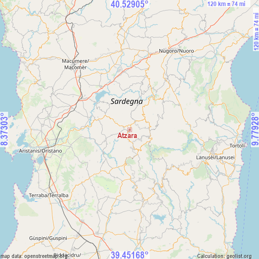
Atzara GPS coordinates[2]
39° 59' 32.964" North, 9° 4' 34.176" East
| Map corner | latitude | longitude |
|---|---|---|
| Upper-left | 40.52905°, | 8.37303° |
| Center: | 39.99249°, | 9.07616° |
| Lower-right: | 39.45168°, | 9.77928° |
| Map W x H: | 119.8×119.8 km | = 74.4×74.4mi |
| max Lat: | 47.04031° ⇑88% North |
| Atzara: | 39.99249° |
| min Lat: | ⇓12% South 35.50142° |
| min Long | Atzara | max Long |
| 6.69888° | 9.07616° | 18.48682° |
| W 19.9%⇐ | ⇒80.1% E |
Elevation
Elevation of Atzara is 556 m = 1824 ft, and this is 249.3 m = 818 ft above average elevation for this country.
| Max E: |
2085 m = 6841 ft | 17.9% |
| Atzara | 556 m 1824 ft | |
| Avg. | 306.7 m = 1006 ft | |
Min E: |
-4 m = -13 ft | 82.1% |
See also: Italy elevation on elevation.city.
Geographical zone
Atzara is located in North temperate zone (between Tropic of Cancer and the Arctic Circle). Distance of this Northern Tropic circle is 1840.8 km =1143.8 mi to South.| Distance of | km | miles | from Atzara |
|---|---|---|---|
| North Pole | 5560.3 | 3455 | to North |
| Arctic Circle | 2954.4 | 1835.8 | to North |
| Tropic Cancer | 1840.8 | 1143.8 | to South |
| Equator | 4446.7 | 2763.1 | to South |


Nearby cities:
15 places around Atzara: (largest is in red/bold)
• Aritzo
10.6 km =6.6 mi,  110°
110°
• Austis
8.8 km =5.5 mi,  6°
6°
• Belvì
9.8 km =6.1 mi, 110°
• Desulo
13.4 km =8.3 mi,  79°
79°
• Gadoni
12.8 km =8 mi,  133°
133°
• Laconi
15.6 km =9.7 mi,  187°
187°
• Meana Sardo
5.3 km =3.3 mi,  182°
182°
• Neoneli
13.6 km =8.5 mi,  306°
306°
• Ortueri
9 km =5.6 mi,  301°
301°
• Ovodda
13.5 km =8.4 mi,  32°
32°
• Samugheo
12.5 km =7.8 mi,  246°
246°
• Sorgono
4.3 km =2.7 mi, 30°
• Teti
12.2 km =7.6 mi,  17°
17°
• Tiana
10.3 km =6.4 mi,  36°
36°
• Tonara
8.9 km =5.5 mi,  66°
66°
Sources, notices
• [Note1] Compared only with cities in Italy existing in our database
• [Src1] Map data: © OpenStreetMap contributors (CC-BY-SA)
• [Src2] Other city data from geonames.org with taken over terms of usage.
• [Src3] Geographical zone / Annual Mean Temperature by Robert A. Rohde @ Wikipedia
