Samugheo geodata
Samugheo (Sardinia) is a seat of a third-order administrative division; located in Italy in Europe/Rome (GMT+2) time zone. With population of 3,183 people, there are 2906 cities with bigger population in this country. Compared to other cities in Italy, 88.3% of cities are located further ↑North; 82.1% of cities are located further →East and 68.5% of cities have lower elevation than Samugheo. Note1


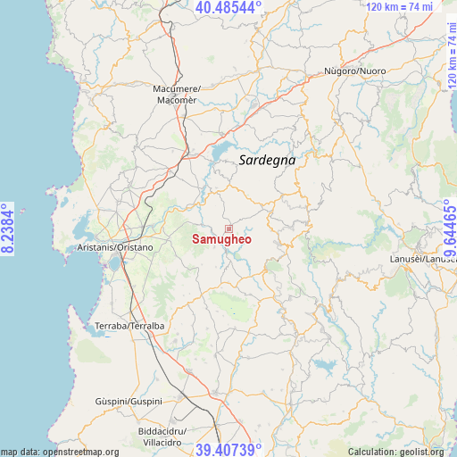
Samugheo GPS coordinates[2]
39° 56' 54.744" North, 8° 56' 29.472" East
| Map corner | latitude | longitude |
|---|---|---|
| Upper-left | 40.48544°, | 8.2384° |
| Center: | 39.94854°, | 8.94152° |
| Lower-right: | 39.40739°, | 9.64465° |
| Map W x H: | 119.9×119.9 km | = 74.5×74.5mi |
| max Lat: | 47.04031° ⇑88.3% North |
| Samugheo: | 39.94854° |
| min Lat: | ⇓11.7% South 35.50142° |
| min Long | Samugheo | max Long |
| 6.69888° | 8.94152° | 18.48682° |
| W 17.9%⇐ | ⇒82.1% E |
Elevation
Elevation of Samugheo is 379 m = 1243 ft, and this is 72.3 m = 237 ft above average elevation for this country.
| Max E: |
2085 m = 6841 ft | 31.5% |
| Samugheo | 379 m 1243 ft | |
| Avg. | 306.7 m = 1006 ft | |
Min E: |
-4 m = -13 ft | 68.5% |
See also: Italy elevation on elevation.city.
Geographical zone
Samugheo is located in North temperate zone (between Tropic of Cancer and the Arctic Circle). Distance of this Northern Tropic circle is 1835.9 km =1140.8 mi to South.| Distance of | km | miles | from Samugheo |
|---|---|---|---|
| North Pole | 5565.2 | 3458.1 | to North |
| Arctic Circle | 2959.3 | 1838.8 | to North |
| Tropic Cancer | 1835.9 | 1140.8 | to South |
| Equator | 4441.9 | 2760.1 | to South |


Nearby cities:
15 places around Samugheo: (largest is in red/bold)
• Allai
6.7 km =4.2 mi,  278°
278°
• Asuni
8.6 km =5.3 mi,  177°
177°
• Atzara
12.5 km =7.8 mi,  66°
66°
• Busachi
10.5 km =6.5 mi,  334°
334°
• Fordongianus
12.3 km =7.6 mi,  294°
294°
• Laconi
14.2 km =8.8 mi,  138°
138°
• Meana Sardo
11.3 km =7 mi,  92°
92°
• Mogorella
11.7 km =7.3 mi,  216°
216°
• Neoneli
12.9 km =8 mi,  1°
1°
• Nureci
14.2 km =8.8 mi,  168°
168°
• Ortueri
10.4 km =6.5 mi,  21°
21°
• Ruinas
6 km =3.7 mi, 218°
• Senis
13.9 km =8.6 mi, 180°
• Ulà Tirso
11.3 km =7 mi,  343°
343°
• Villa Sant'Antonio
10.5 km =6.5 mi,  198°
198°
Sources, notices
• [Note1] Compared only with cities in Italy existing in our database
• [Src1] Map data: © OpenStreetMap contributors (CC-BY-SA)
• [Src2] Other city data from geonames.org with taken over terms of usage.
• [Src3] Geographical zone / Annual Mean Temperature by Robert A. Rohde @ Wikipedia
