Allai geodata
Allai (Sardinia) is a seat of a third-order administrative division; located in Italy in Europe/Rome (GMT+2) time zone. With population of 354 people, there are 10463 cities with bigger population in this country. Compared to other cities in Italy, 88.2% of cities are located further ↑North; 83.3% of cities are located further →East and 77.9% of cities have higher elevation than Allai. Note1


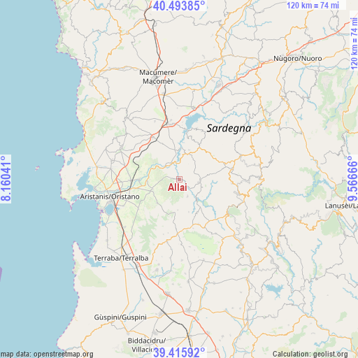
Allai GPS coordinates[2]
39° 57' 25.236" North, 8° 51' 48.744" East
| Map corner | latitude | longitude |
|---|---|---|
| Upper-left | 40.49385°, | 8.16041° |
| Center: | 39.95701°, | 8.86354° |
| Lower-right: | 39.41592°, | 9.56666° |
| Map W x H: | 119.9×119.9 km | = 74.5×74.5mi |
| max Lat: | 47.04031° ⇑88.2% North |
| Allai: | 39.95701° |
| min Lat: | ⇓11.8% South 35.50142° |
| min Long | Allai | max Long |
| 6.69888° | 8.86354° | 18.48682° |
| W 16.7%⇐ | ⇒83.3% E |
Elevation
Elevation of Allai is 60 m = 197 ft, and this is 246.7 m = 809 ft below average elevation for this country.
| Max E: |
2085 m = 6841 ft | 77.9% |
| Avg. | 306.7 m = 1006 ft | |
| Allai | 60 m = 197 ft | |
Min E: |
-4 m = -13 ft | 22.1% |
See also: Italy elevation on elevation.city.
Geographical zone
Allai is located in North temperate zone (between Tropic of Cancer and the Arctic Circle). Distance of this Northern Tropic circle is 1836.9 km =1141.4 mi to South.| Distance of | km | miles | from Allai |
|---|---|---|---|
| North Pole | 5564.3 | 3457.5 | to North |
| Arctic Circle | 2958.4 | 1838.3 | to North |
| Tropic Cancer | 1836.9 | 1141.4 | to South |
| Equator | 4442.8 | 2760.6 | to South |


Nearby cities:
15 places around Allai: (largest is in red/bold)
• Asuni
11.9 km =7.4 mi,  143°
143°
• Busachi
8.8 km =5.5 mi,  13°
13°
• Fordongianus
6.2 km =3.9 mi,  312°
312°
• Mogorella
10.3 km =6.4 mi,  182°
182°
• Ollastra
11 km =6.8 mi,  266°
266°
• Ortueri
13.6 km =8.5 mi,  50°
50°
• Ruinas
6.3 km =3.9 mi,  153°
153°
• Samugheo
6.7 km =4.2 mi,  98°
98°
• Siamanna
9.6 km =6 mi,  244°
244°
• Siapiccia
9.2 km =5.7 mi,  249°
249°
• Ulà Tirso
10.4 km =6.5 mi,  18°
18°
• Villa Sant'Antonio
11.4 km =7.1 mi,  163°
163°
• Villanova Truschedu
10.1 km =6.3 mi,  290°
290°
• Villaurbana
10.8 km =6.7 mi,  222°
222°
• Zerfaliu
13.1 km =8.1 mi, 271°
Sources, notices
• [Note1] Compared only with cities in Italy existing in our database
• [Src1] Map data: © OpenStreetMap contributors (CC-BY-SA)
• [Src2] Other city data from geonames.org with taken over terms of usage.
• [Src3] Geographical zone / Annual Mean Temperature by Robert A. Rohde @ Wikipedia
