Mogorella geodata
Mogorella (Sardinia) is a seat of a third-order administrative division; located in Italy in Europe/Rome (GMT+2) time zone. With population of 458 people, there are 10058 cities with bigger population in this country. Compared to other cities in Italy, 88.7% of cities are located further ↑North; 83.4% of cities are located further →East and 58.1% of cities have lower elevation than Mogorella. Note1


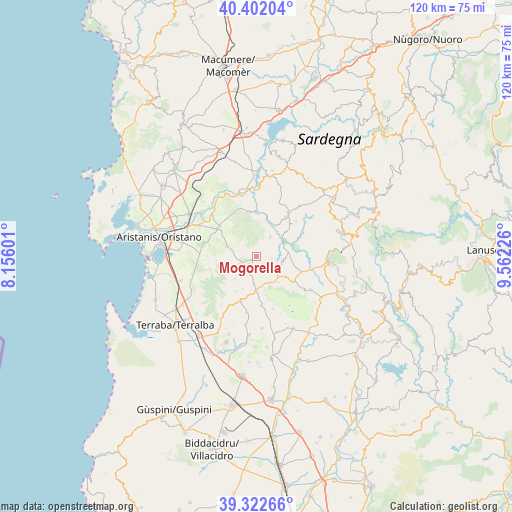
Mogorella GPS coordinates[2]
39° 51' 52.092" North, 8° 51' 32.868" East
| Map corner | latitude | longitude |
|---|---|---|
| Upper-left | 40.40204°, | 8.15601° |
| Center: | 39.86447°, | 8.85913° |
| Lower-right: | 39.32266°, | 9.56226° |
| Map W x H: | 120×120 km | = 74.6×74.6mi |
| max Lat: | 47.04031° ⇑88.7% North |
| Mogorella: | 39.86447° |
| min Lat: | ⇓11.3% South 35.50142° |
| min Long | Mogorella | max Long |
| 6.69888° | 8.85913° | 18.48682° |
| W 16.6%⇐ | ⇒83.4% E |
Elevation
Elevation of Mogorella is 286 m = 938 ft, and this is 20.7 m = 68 ft below average elevation for this country.
| Max E: |
2085 m = 6841 ft | 41.9% |
| Avg. | 306.7 m = 1006 ft | |
| Mogorella | 286 m = 938 ft | |
Min E: |
-4 m = -13 ft | 58.1% |
See also: Italy elevation on elevation.city.
Geographical zone
Mogorella is located in North temperate zone (between Tropic of Cancer and the Arctic Circle). Distance of this Northern Tropic circle is 1826.6 km =1135 mi to South.| Distance of | km | miles | from Mogorella |
|---|---|---|---|
| North Pole | 5574.5 | 3463.8 | to North |
| Arctic Circle | 2968.7 | 1844.7 | to North |
| Tropic Cancer | 1826.6 | 1135 | to South |
| Equator | 4432.5 | 2754.2 | to South |


Nearby cities:
15 places around Mogorella: (largest is in red/bold)
• Albagiara
8.6 km =5.3 mi,  178°
178°
• Ales
11.3 km =7 mi,  199°
199°
• Allai
10.3 km =6.4 mi,  2°
2°
• Assolo
8 km =5 mi,  140°
140°
• Asuni
7.5 km =4.7 mi,  84°
84°
• Nureci
10.9 km =6.8 mi,  114°
114°
• Pau
9.4 km =5.8 mi,  210°
210°
• Ruinas
5.7 km =3.5 mi,  34°
34°
• Senis
8.2 km =5.1 mi,  123°
123°
• Siamanna
10.3 km =6.4 mi,  306°
306°
• Siapiccia
10.8 km =6.7 mi, 310°
• Usellus
6.3 km =3.9 mi,  185°
185°
• Villa Sant'Antonio
3.7 km =2.3 mi,  99°
99°
• Villa Verde
8.3 km =5.2 mi, 202°
• Villaurbana
7.3 km =4.5 mi,  288°
288°
Sources, notices
• [Note1] Compared only with cities in Italy existing in our database
• [Src1] Map data: © OpenStreetMap contributors (CC-BY-SA)
• [Src2] Other city data from geonames.org with taken over terms of usage.
• [Src3] Geographical zone / Annual Mean Temperature by Robert A. Rohde @ Wikipedia
