Arzignano geodata
Arzignano (Veneto) is a seat of a third-order administrative division; located in Italy in Europe/Rome (GMT+2) time zone. With population of 21,247 people, there are 412 cities with bigger population in this country. Compared to other cities in Italy, 74.3% of cities are located further ↓South; 52.7% of cities are located further →East and 66.7% of cities have higher elevation than Arzignano. Note1


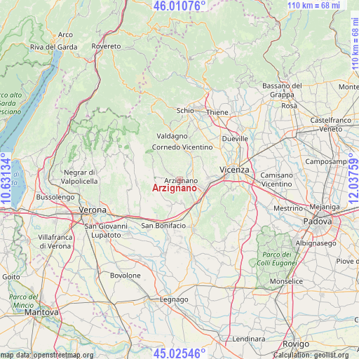
Arzignano GPS coordinates[2]
45° 31' 12.972" North, 11° 20' 4.056" East
| Map corner | latitude | longitude |
|---|---|---|
| Upper-left | 46.01076°, | 10.63134° |
| Center: | 45.52027°, | 11.33446° |
| Lower-right: | 45.02546°, | 12.03759° |
| Map W x H: | 109.6×109.6 km | = 68.1×68.1mi |
| max Lat: | 47.04031° ⇑25.7% North |
| Arzignano: | 45.52027° |
| min Lat: | ⇓74.3% South 35.50142° |
| min Long | Arzignano | max Long |
| 6.69888° | 11.33446° | 18.48682° |
| W 47.3%⇐ | ⇒52.7% E |
Elevation
Elevation of Arzignano is 117 m = 384 ft, and this is 189.7 m = 622 ft below average elevation for this country.
| Max E: |
2085 m = 6841 ft | 66.7% |
| Avg. | 306.7 m = 1006 ft | |
| Arzignano | 117 m = 384 ft | |
Min E: |
-4 m = -13 ft | 33.3% |
See also: Italy elevation on elevation.city.
Geographical zone
Arzignano is located in North temperate zone (between Tropic of Cancer and the Arctic Circle). Distance of this North polar circle is 2339.8 km =1453.9 mi to North.| Distance of | km | miles | from Arzignano |
|---|---|---|---|
| North Pole | 4945.7 | 3073.1 | to North |
| Arctic Circle | 2339.8 | 1453.9 | to North |
| Tropic Cancer | 2455.5 | 1525.8 | to South |
| Equator | 5061.4 | 3145 | to South |


Nearby cities:
15 places around Arzignano: (largest is in red/bold)
• Brogliano
8 km =5 mi,  17°
17°
• Castelgomberto
8.2 km =5.1 mi,  31°
31°
• Chiampo
5 km =3.1 mi,  306°
306°
• Gambellara
6.7 km =4.2 mi,  176°
176°
• Montebello Vicentino
7.8 km =4.8 mi,  151°
151°
• Montecchia di Crosara
7.6 km =4.7 mi,  235°
235°
• Montecchio Maggiore-Alte Ceccato
6.3 km =3.9 mi,  106°
106°
• Montorso Vicentino
3.8 km =2.4 mi, 148°
• Nogarole Vicentino
5.7 km =3.5 mi,  320°
320°
• Roncà
5.5 km =3.4 mi,  215°
215°
• San Giovanni Ilarione
7.6 km =4.7 mi,  269°
269°
• Terrossa
6.4 km =4 mi,  191°
191°
• Tezze
3.2 km =2 mi,  61°
61°
• Trissino
5.5 km =3.4 mi,  36°
36°
• Zermeghedo
5.8 km =3.6 mi, 147°
Sources, notices
• [Note1] Compared only with cities in Italy existing in our database
• [Src1] Map data: © OpenStreetMap contributors (CC-BY-SA)
• [Src2] Other city data from geonames.org with taken over terms of usage.
• [Src3] Geographical zone / Annual Mean Temperature by Robert A. Rohde @ Wikipedia
