Zagarolo geodata
Zagarolo (Latium) is a seat of a third-order administrative division; located in Italy in Europe/Rome (GMT+2) time zone. With population of 11,509 people, there are 816 cities with bigger population in this country. Compared to other cities in Italy, 71.7% of cities are located further ↑North; 66.3% of cities are located further ←West and 58.4% of cities have lower elevation than Zagarolo. Note1
Administrative division(s):
- Level 1: Latium
- Level 2: Città metropolitana di Roma Capitale
- Level 3: Zagarolo


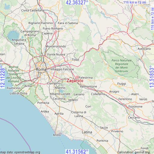
Zagarolo GPS coordinates[2]
41° 50' 29.724" North, 12° 48' 55.44" East
| Map corner | latitude | longitude |
|---|---|---|
| Upper-left | 42.36327°, | 12.11228° |
| Center: | 41.84159°, | 12.8154° |
| Lower-right: | 41.31562°, | 13.51853° |
| Map W x H: | 116.5×116.5 km | = 72.4×72.4mi |
| max Lat: | 47.04031° ⇑71.7% North |
| Zagarolo: | 41.84159° |
| min Lat: | ⇓28.3% South 35.50142° |
| min Long | Zagarolo | max Long |
| 6.69888° | 12.8154° | 18.48682° |
| W 66.3%⇐ | ⇒33.7% E |
Elevation
Elevation of Zagarolo is 288 m = 945 ft, and this is 18.7 m = 61 ft below average elevation for this country.
| Max E: |
2085 m = 6841 ft | 41.6% |
| Avg. | 306.7 m = 1006 ft | |
| Zagarolo | 288 m = 945 ft | |
Min E: |
-4 m = -13 ft | 58.4% |
See also: Italy elevation on elevation.city.
Geographical zone
Zagarolo is located in North temperate zone (between Tropic of Cancer and the Arctic Circle). Distance of this Northern Tropic circle is 2046.4 km =1271.6 mi to South.| Distance of | km | miles | from Zagarolo |
|---|---|---|---|
| North Pole | 5354.7 | 3327.3 | to North |
| Arctic Circle | 2748.8 | 1708 | to North |
| Tropic Cancer | 2046.4 | 1271.6 | to South |
| Equator | 4652.3 | 2890.8 | to South |


Nearby cities:
15 places around Zagarolo: (largest is in red/bold)
• Carchitti
6.2 km =3.9 mi,  169°
169°
• Castel San Pietro Romano
6.6 km =4.1 mi,  86°
86°
• Colle Mainello
3.9 km =2.4 mi,  323°
323°
• Colle Spina
7.1 km =4.4 mi,  158°
158°
• Colle di Fuori
4.6 km =2.9 mi,  188°
188°
• Colonna
5.1 km =3.2 mi,  261°
261°
• Gallicano nel Lazio
3 km =1.9 mi,  33°
33°
• Labico
7.1 km =4.4 mi,  139°
139°
• Laghetto
7.7 km =4.8 mi,  282°
282°
• Monte Porzio Catone
8.9 km =5.5 mi,  251°
251°
• Montecompatri
7.4 km =4.6 mi,  240°
240°
• Palestrina
5.6 km =3.5 mi,  100°
100°
• Poli
8.2 km =5.1 mi,  49°
49°
• San Cesareo
2.4 km =1.5 mi,  201°
201°
• Valle Martella
7 km =4.3 mi,  305°
305°
Sources, notices
• [Note1] Compared only with cities in Italy existing in our database
• [Src1] Map data: © OpenStreetMap contributors (CC-BY-SA)
• [Src2] Other city data from geonames.org with taken over terms of usage.
• [Src3] Geographical zone / Annual Mean Temperature by Robert A. Rohde @ Wikipedia
