Labico geodata
Labico (Latium) is a seat of a third-order administrative division; located in Italy in Europe/Rome (GMT+2) time zone. With population of 4,408 people, there are 2188 cities with bigger population in this country. Compared to other cities in Italy, 72% of cities are located further ↑North; 66.9% of cities are located further ←West and 66.5% of cities have lower elevation than Labico. Note1
Administrative division(s):
- Level 1: Latium
- Level 2: Città metropolitana di Roma Capitale
- Level 3: Labico


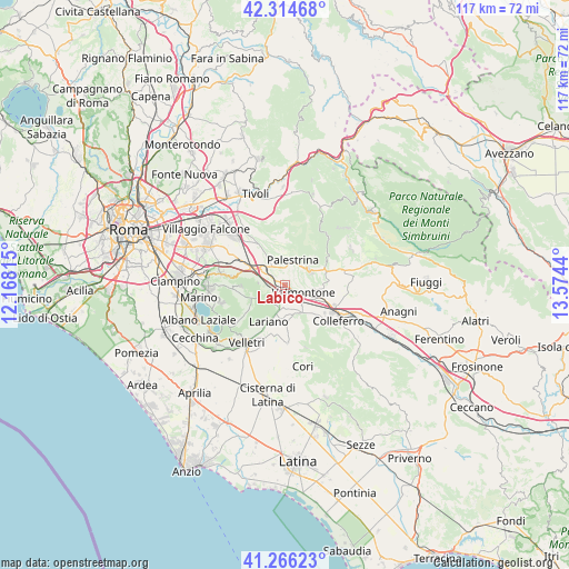
Labico GPS coordinates[2]
41° 47' 33.36" North, 12° 52' 16.572" East
| Map corner | latitude | longitude |
|---|---|---|
| Upper-left | 42.31468°, | 12.16815° |
| Center: | 41.7926°, | 12.87127° |
| Lower-right: | 41.26623°, | 13.5744° |
| Map W x H: | 116.6×116.6 km | = 72.5×72.5mi |
| max Lat: | 47.04031° ⇑72% North |
| Labico: | 41.7926° |
| min Lat: | ⇓28% South 35.50142° |
| min Long | Labico | max Long |
| 6.69888° | 12.87127° | 18.48682° |
| W 66.9%⇐ | ⇒33.1% E |
Elevation
Elevation of Labico is 358 m = 1175 ft, and this is 51.3 m = 168 ft above average elevation for this country.
| Max E: |
2085 m = 6841 ft | 33.5% |
| Labico | 358 m 1175 ft | |
| Avg. | 306.7 m = 1006 ft | |
Min E: |
-4 m = -13 ft | 66.5% |
See also: Italy elevation on elevation.city.
Geographical zone
Labico is located in North temperate zone (between Tropic of Cancer and the Arctic Circle). Distance of this Northern Tropic circle is 2041 km =1268.2 mi to South.| Distance of | km | miles | from Labico |
|---|---|---|---|
| North Pole | 5360.2 | 3330.7 | to North |
| Arctic Circle | 2754.3 | 1711.4 | to North |
| Tropic Cancer | 2041 | 1268.2 | to South |
| Equator | 4646.9 | 2887.4 | to South |


Nearby cities:
15 places around Labico: (largest is in red/bold)
• Artena
6.4 km =4 mi,  152°
152°
• Carchitti
3.5 km =2.2 mi,  259°
259°
• Castel San Pietro Romano
6.2 km =3.9 mi,  18°
18°
• Cave
6.3 km =3.9 mi,  64°
64°
• Colle Spina
2.3 km =1.4 mi,  239°
239°
• Colle di Fuori
5.4 km =3.4 mi,  279°
279°
• Colubro
6.4 km =4 mi,  182°
182°
• Cruci
6.4 km =4 mi,  96°
96°
• Macere
5 km =3.1 mi,  192°
192°
• Palestrina
4.5 km =2.8 mi,  11°
11°
• Rocca di Cave
8.5 km =5.3 mi,  45°
45°
• San Bartolomeo
4.5 km =2.8 mi, 58°
• San Cesareo
6.4 km =4 mi,  299°
299°
• Valmontone
4.5 km =2.8 mi,  118°
118°
• Zagarolo
7.1 km =4.4 mi,  319°
319°
Sources, notices
• [Note1] Compared only with cities in Italy existing in our database
• [Src1] Map data: © OpenStreetMap contributors (CC-BY-SA)
• [Src2] Other city data from geonames.org with taken over terms of usage.
• [Src3] Geographical zone / Annual Mean Temperature by Robert A. Rohde @ Wikipedia
