Palestrina geodata
Palestrina (Latium) is a seat of a third-order administrative division; located in Italy in Europe/Rome (GMT+2) time zone. With population of 14,925 people, there are 604 cities with bigger population in this country. Compared to other cities in Italy, 71.8% of cities are located further ↑North; 67% of cities are located further ←West and 71.5% of cities have lower elevation than Palestrina. Note1
Administrative division(s):
- Level 1: Latium
- Level 2: Città metropolitana di Roma Capitale
- Level 3: Palestrina


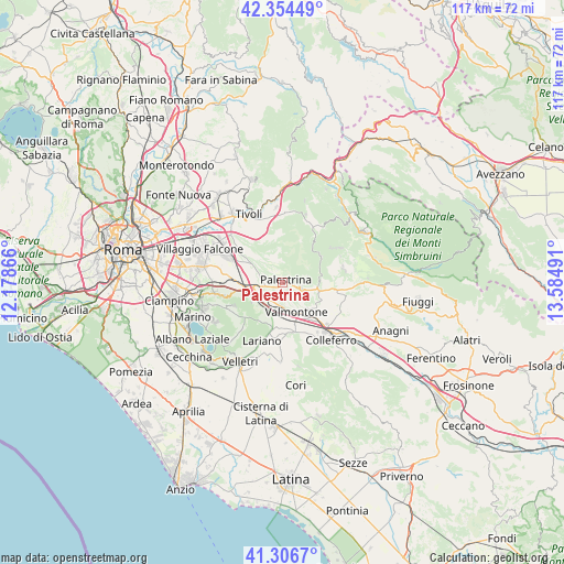
Palestrina GPS coordinates[2]
41° 49' 57.864" North, 12° 52' 54.408" East
| Map corner | latitude | longitude |
|---|---|---|
| Upper-left | 42.35449°, | 12.17866° |
| Center: | 41.83274°, | 12.88178° |
| Lower-right: | 41.3067°, | 13.58491° |
| Map W x H: | 116.5×116.5 km | = 72.4×72.4mi |
| max Lat: | 47.04031° ⇑71.8% North |
| Palestrina: | 41.83274° |
| min Lat: | ⇓28.2% South 35.50142° |
| min Long | Palestrina | max Long |
| 6.69888° | 12.88178° | 18.48682° |
| W 67%⇐ | ⇒33% E |
Elevation
Elevation of Palestrina is 410 m = 1345 ft, and this is 103.3 m = 339 ft above average elevation for this country.
| Max E: |
2085 m = 6841 ft | 28.5% |
| Palestrina | 410 m 1345 ft | |
| Avg. | 306.7 m = 1006 ft | |
Min E: |
-4 m = -13 ft | 71.5% |
See also: Italy elevation on elevation.city.
Geographical zone
Palestrina is located in North temperate zone (between Tropic of Cancer and the Arctic Circle). Distance of this Northern Tropic circle is 2045.4 km =1271 mi to South.| Distance of | km | miles | from Palestrina |
|---|---|---|---|
| North Pole | 5355.7 | 3327.9 | to North |
| Arctic Circle | 2749.8 | 1708.6 | to North |
| Tropic Cancer | 2045.4 | 1271 | to South |
| Equator | 4651.4 | 2890.2 | to South |


Nearby cities:
15 places around Palestrina: (largest is in red/bold)
• Capranica Prenestina
6.6 km =4.1 mi,  59°
59°
• Carchitti
6.7 km =4.2 mi,  220°
220°
• Castel San Pietro Romano
1.8 km =1.1 mi,  36°
36°
• Cave
5.2 km =3.2 mi,  109°
109°
• Colle Spina
6.3 km =3.9 mi,  206°
206°
• Colle di Fuori
7.1 km =4.4 mi,  240°
240°
• Gallicano nel Lazio
5.2 km =3.2 mi,  312°
312°
• Genazzano
7.5 km =4.7 mi,  93°
93°
• Labico
4.5 km =2.8 mi,  191°
191°
• Poli
6.3 km =3.9 mi,  6°
6°
• Rocca di Cave
5.4 km =3.4 mi,  74°
74°
• San Bartolomeo
3.6 km =2.2 mi,  125°
125°
• San Cesareo
6.5 km =4 mi,  258°
258°
• Valmontone
7.3 km =4.5 mi,  155°
155°
• Zagarolo
5.6 km =3.5 mi,  280°
280°
Sources, notices
• [Note1] Compared only with cities in Italy existing in our database
• [Src1] Map data: © OpenStreetMap contributors (CC-BY-SA)
• [Src2] Other city data from geonames.org with taken over terms of usage.
• [Src3] Geographical zone / Annual Mean Temperature by Robert A. Rohde @ Wikipedia
