Gallicano nel Lazio geodata
Gallicano nel Lazio (Latium) is a seat of a third-order administrative division; located in Italy in Europe/Rome (GMT+2) time zone. With population of 3,776 people, there are 2524 cities with bigger population in this country. Compared to other cities in Italy, 71.5% of cities are located further ↑North; 66.5% of cities are located further ←West and 60.6% of cities have lower elevation than Gallicano nel Lazio. Note1
Administrative division(s):
- Level 1: Latium
- Level 2: Città metropolitana di Roma Capitale
- Level 3: Gallicano nel Lazio


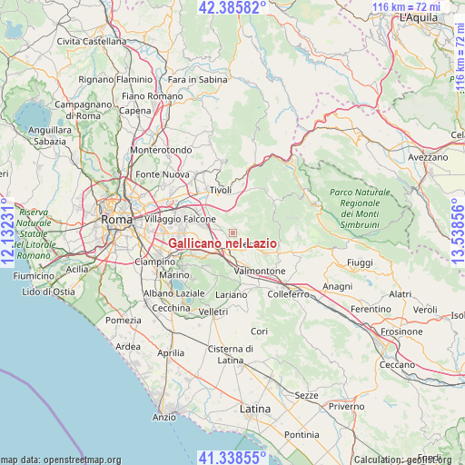
Gallicano nel Lazio GPS coordinates[2]
41° 51' 51.588" North, 12° 50' 7.548" East
| Map corner | latitude | longitude |
|---|---|---|
| Upper-left | 42.38582°, | 12.13231° |
| Center: | 41.86433°, | 12.83543° |
| Lower-right: | 41.33855°, | 13.53856° |
| Map W x H: | 116.4×116.4 km | = 72.3×72.3mi |
| max Lat: | 47.04031° ⇑71.5% North |
| Gallicano nel Lazio: | 41.86433° |
| min Lat: | ⇓28.5% South 35.50142° |
| min Long | Gallicano nel L | max Long |
| 6.69888° | 12.83543° | 18.48682° |
| W 66.5%⇐ | ⇒33.5% E |
Elevation
Elevation of Gallicano nel Lazio is 304 m = 997 ft, and this is 2.7 m = 9 ft below average elevation for this country.
| Max E: |
2085 m = 6841 ft | 39.4% |
| Avg. | 306.7 m = 1006 ft | |
| Gallicano nel Lazio | 304 m = 997 ft | |
Min E: |
-4 m = -13 ft | 60.6% |
See also: Italy elevation on elevation.city.
Geographical zone
Gallicano nel Lazio is located in North temperate zone (between Tropic of Cancer and the Arctic Circle). Distance of this Northern Tropic circle is 2049 km =1273.2 mi to South.| Distance of | km | miles | from Gallicano nel Lazio |
|---|---|---|---|
| North Pole | 5352.2 | 3325.7 | to North |
| Arctic Circle | 2746.3 | 1706.5 | to North |
| Tropic Cancer | 2049 | 1273.2 | to South |
| Equator | 4654.9 | 2892.4 | to South |


Nearby cities:
15 places around Gallicano nel Lazio: (largest is in red/bold)
• Carchitti
8.6 km =5.3 mi,  183°
183°
• Casape
6.3 km =3.9 mi,  41°
41°
• Castel San Pietro Romano
5.3 km =3.3 mi,  112°
112°
• Colle Mainello
4 km =2.5 mi,  278°
278°
• Colle Spina
9.2 km =5.7 mi,  173°
173°
• Colle di Fuori
7.4 km =4.6 mi,  198°
198°
• Colonna
7.4 km =4.6 mi,  243°
243°
• Labico
8.5 km =5.3 mi,  159°
159°
• Palestrina
5.2 km =3.2 mi,  132°
132°
• Poli
5.3 km =3.3 mi,  58°
58°
• San Bartolomeo
8.8 km =5.5 mi, 129°
• San Cesareo
5.4 km =3.4 mi,  208°
208°
• San Gregorio da Sassola
6.9 km =4.3 mi,  28°
28°
• Valle Martella
7.5 km =4.7 mi, 281°
• Zagarolo
3 km =1.9 mi, 213°
Sources, notices
• [Note1] Compared only with cities in Italy existing in our database
• [Src1] Map data: © OpenStreetMap contributors (CC-BY-SA)
• [Src2] Other city data from geonames.org with taken over terms of usage.
• [Src3] Geographical zone / Annual Mean Temperature by Robert A. Rohde @ Wikipedia
