Villa Latina geodata
Villa Latina (Latium) is a seat of a third-order administrative division; located in Italy in Europe/Rome (GMT+2) time zone. With population of 909 people, there are 7095 cities with bigger population in this country. Compared to other cities in Italy, 73.8% of cities are located further ↑North; 76.9% of cities are located further ←West and 72.8% of cities have lower elevation than Villa Latina. Note1


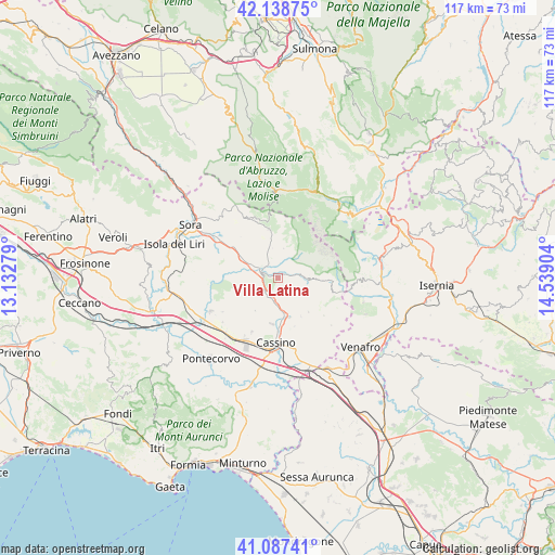
Villa Latina GPS coordinates[2]
41° 36' 54.792" North, 13° 50' 9.276" East
| Map corner | latitude | longitude |
|---|---|---|
| Upper-left | 42.13875°, | 13.13279° |
| Center: | 41.61522°, | 13.83591° |
| Lower-right: | 41.08741°, | 14.53904° |
| Map W x H: | 116.9×116.9 km | = 72.6×72.6mi |
| max Lat: | 47.04031° ⇑73.8% North |
| Villa Latina: | 41.61522° |
| min Lat: | ⇓26.2% South 35.50142° |
| min Long | Villa Latina | max Long |
| 6.69888° | 13.83591° | 18.48682° |
| W 76.9%⇐ | ⇒23.1% E |
Elevation
Elevation of Villa Latina is 423 m = 1388 ft, and this is 116.3 m = 382 ft above average elevation for this country.
| Max E: |
2085 m = 6841 ft | 27.2% |
| Villa Latina | 423 m 1388 ft | |
| Avg. | 306.7 m = 1006 ft | |
Min E: |
-4 m = -13 ft | 72.8% |
See also: Italy elevation on elevation.city.
Geographical zone
Villa Latina is located in North temperate zone (between Tropic of Cancer and the Arctic Circle). Distance of this Northern Tropic circle is 2021.3 km =1256 mi to South.| Distance of | km | miles | from Villa Latina |
|---|---|---|---|
| North Pole | 5379.9 | 3342.9 | to North |
| Arctic Circle | 2774 | 1723.7 | to North |
| Tropic Cancer | 2021.3 | 1256 | to South |
| Equator | 4627.2 | 2875.2 | to South |


Nearby cities:
15 places around Villa Latina: (largest is in red/bold)
• Atina
3.1 km =1.9 mi,  279°
279°
• Atina Inferiore
3.8 km =2.4 mi,  290°
290°
• Belmonte Castello
4.5 km =2.8 mi,  201°
201°
• Caira
9.2 km =5.7 mi,  189°
189°
• Casalattico
9.2 km =5.7 mi,  274°
274°
• Casalvieri
10.4 km =6.5 mi, 281°
• Gallinaro
5.4 km =3.4 mi,  324°
324°
• Picinisco
4.3 km =2.7 mi,  38°
38°
• San Biagio Saracinisco
7.6 km =4.7 mi,  91°
91°
• San Donato Val di Comino
10.4 km =6.5 mi,  349°
349°
• Sant'Elia Fiumerapido
9.4 km =5.8 mi,  166°
166°
• Settefrati
6.3 km =3.9 mi,  11°
11°
• Terelle
8.5 km =5.3 mi,  214°
214°
• Vallerotonda
9.6 km =6 mi,  137°
137°
• Valvori
7.2 km =4.5 mi, 141°
Sources, notices
• [Note1] Compared only with cities in Italy existing in our database
• [Src1] Map data: © OpenStreetMap contributors (CC-BY-SA)
• [Src2] Other city data from geonames.org with taken over terms of usage.
• [Src3] Geographical zone / Annual Mean Temperature by Robert A. Rohde @ Wikipedia
