Caira geodata
Caira (Latium) is a populated place; located in Italy in Europe/Rome (GMT+2) time zone. With population of 1,586 people, there are 4931 cities with bigger population in this country. Compared to other cities in Italy, 74.5% of cities are located further ↑North; 76.7% of cities are located further ←West and 60.4% of cities have higher elevation than Caira. Note1


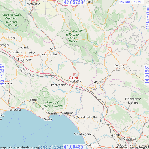
Caira GPS coordinates[2]
41° 31' 59.988" North, 13° 49' 0.012" East
| Map corner | latitude | longitude |
|---|---|---|
| Upper-left | 42.05753°, | 13.11355° |
| Center: | 41.53333°, | 13.81667° |
| Lower-right: | 41.00485°, | 14.5198° |
| Map W x H: | 117×117 km | = 72.7×72.7mi |
| max Lat: | 47.04031° ⇑74.5% North |
| Caira: | 41.53333° |
| min Lat: | ⇓25.5% South 35.50142° |
| min Long | Caira | max Long |
| 6.69888° | 13.81667° | 18.48682° |
| W 76.7%⇐ | ⇒23.3% E |
Elevation
Elevation of Caira is 160 m = 525 ft, and this is 146.7 m = 481 ft below average elevation for this country.
| Max E: |
2085 m = 6841 ft | 60.4% |
| Avg. | 306.7 m = 1006 ft | |
| Caira | 160 m = 525 ft | |
Min E: |
-4 m = -13 ft | 39.6% |
See also: Italy elevation on elevation.city.
Geographical zone
Caira is located in North temperate zone (between Tropic of Cancer and the Arctic Circle). Distance of this Northern Tropic circle is 2012.2 km =1250.3 mi to South.| Distance of | km | miles | from Caira |
|---|---|---|---|
| North Pole | 5389 | 3348.6 | to North |
| Arctic Circle | 2783.1 | 1729.3 | to North |
| Tropic Cancer | 2012.2 | 1250.3 | to South |
| Equator | 4618.1 | 2869.6 | to South |


Nearby cities:
15 places around Caira: (largest is in red/bold)
• Atina
9.8 km =6.1 mi,  351°
351°
• Belmonte Castello
4.9 km =3 mi,  359°
359°
• Cappella Morrone
6.6 km =4.1 mi,  138°
138°
• Cassino
5.4 km =3.4 mi,  169°
169°
• Cervaro
9.1 km =5.7 mi,  128°
128°
• Pastenelle-Pacitti-Sprumaro
7.6 km =4.7 mi, 133°
• Piedimonte San Germano
6.8 km =4.2 mi,  234°
234°
• Piedimonte San Germano Alta
6.5 km =4 mi,  240°
240°
• San Bartolomeo
6.6 km =4.1 mi,  148°
148°
• Sant'Elia Fiumerapido
3.8 km =2.4 mi,  90°
90°
• Terelle
3.8 km =2.4 mi,  303°
303°
• Vallerotonda
8.3 km =5.2 mi,  76°
76°
• Valvori
7 km =4.3 mi,  60°
60°
• Villa Latina
9.2 km =5.7 mi,  9°
9°
• Villa Santa Lucia
4.6 km =2.9 mi, 239°
Sources, notices
• [Note1] Compared only with cities in Italy existing in our database
• [Src1] Map data: © OpenStreetMap contributors (CC-BY-SA)
• [Src2] Other city data from geonames.org with taken over terms of usage.
• [Src3] Geographical zone / Annual Mean Temperature by Robert A. Rohde @ Wikipedia
