Vallerotonda geodata
Vallerotonda (Latium) is a seat of a third-order administrative division; located in Italy in Europe/Rome (GMT+2) time zone. With population of 354 people, there are 10463 cities with bigger population in this country. Compared to other cities in Italy, 74.3% of cities are located further ↑North; 77.6% of cities are located further ←West and 83.8% of cities have lower elevation than Vallerotonda. Note1


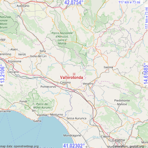
Vallerotonda GPS coordinates[2]
41° 33' 4.86" North, 13° 54' 49.392" East
| Map corner | latitude | longitude |
|---|---|---|
| Upper-left | 42.0754°, | 13.2106° |
| Center: | 41.55135°, | 13.91372° |
| Lower-right: | 41.02302°, | 14.61685° |
| Map W x H: | 117×117 km | = 72.7×72.7mi |
| max Lat: | 47.04031° ⇑74.3% North |
| Vallerotonda: | 41.55135° |
| min Lat: | ⇓25.7% South 35.50142° |
| min Long | Vallerotonda | max Long |
| 6.69888° | 13.91372° | 18.48682° |
| W 77.6%⇐ | ⇒22.4% E |
Elevation
Elevation of Vallerotonda is 588 m = 1929 ft, and this is 281.3 m = 923 ft above average elevation for this country.
| Max E: |
2085 m = 6841 ft | 16.2% |
| Vallerotonda | 588 m 1929 ft | |
| Avg. | 306.7 m = 1006 ft | |
Min E: |
-4 m = -13 ft | 83.8% |
See also: Italy elevation on elevation.city.
Geographical zone
Vallerotonda is located in North temperate zone (between Tropic of Cancer and the Arctic Circle). Distance of this Northern Tropic circle is 2014.2 km =1251.6 mi to South.| Distance of | km | miles | from Vallerotonda |
|---|---|---|---|
| North Pole | 5387 | 3347.3 | to North |
| Arctic Circle | 2781.1 | 1728.1 | to North |
| Tropic Cancer | 2014.2 | 1251.6 | to South |
| Equator | 4620.1 | 2870.8 | to South |


Nearby cities:
15 places around Vallerotonda: (largest is in red/bold)
• Acquafondata
3.4 km =2.1 mi,  106°
106°
• Belmonte Castello
8.6 km =5.3 mi,  289°
289°
• Caira
8.3 km =5.2 mi,  256°
256°
• Cappella Morrone
7.9 km =4.9 mi,  207°
207°
• Cassino
10.2 km =6.3 mi,  224°
224°
• Cervaro
7.7 km =4.8 mi,  187°
187°
• Conca Casale
10 km =6.2 mi,  128°
128°
• Pastenelle-Pacitti-Sprumaro
7.6 km =4.7 mi,  199°
199°
• San Bartolomeo
9 km =5.6 mi, 211°
• San Biagio Saracinisco
7 km =4.3 mi,  9°
9°
• San Vittore del Lazio
10.1 km =6.3 mi,  170°
170°
• Sant'Elia Fiumerapido
4.7 km =2.9 mi,  244°
244°
• Valvori
2.5 km =1.6 mi,  305°
305°
• Villa Latina
9.6 km =6 mi,  317°
317°
• Viticuso
5.6 km =3.5 mi,  122°
122°
Sources, notices
• [Note1] Compared only with cities in Italy existing in our database
• [Src1] Map data: © OpenStreetMap contributors (CC-BY-SA)
• [Src2] Other city data from geonames.org with taken over terms of usage.
• [Src3] Geographical zone / Annual Mean Temperature by Robert A. Rohde @ Wikipedia
