Atina Inferiore geodata
Atina Inferiore (Latium) is a populated place; located in Italy in Europe/Rome (GMT+2) time zone. With population of 1,426 people, there are 5304 cities with bigger population in this country. Compared to other cities in Italy, 73.7% of cities are located further ↑North; 76.5% of cities are located further ←West and 66.2% of cities have lower elevation than Atina Inferiore. Note1


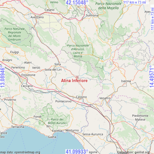
Atina Inferiore GPS coordinates[2]
41° 37' 37.38" North, 13° 47' 33.288" East
| Map corner | latitude | longitude |
|---|---|---|
| Upper-left | 42.15048°, | 13.08946° |
| Center: | 41.62705°, | 13.79258° |
| Lower-right: | 41.09933°, | 14.49571° |
| Map W x H: | 116.9×116.9 km | = 72.6×72.6mi |
| max Lat: | 47.04031° ⇑73.7% North |
| Atina Inferiore: | 41.62705° |
| min Lat: | ⇓26.3% South 35.50142° |
| min Long | Atina Inferiore | max Long |
| 6.69888° | 13.79258° | 18.48682° |
| W 76.5%⇐ | ⇒23.5% E |
Elevation
Elevation of Atina Inferiore is 355 m = 1165 ft, and this is 48.3 m = 158 ft above average elevation for this country.
| Max E: |
2085 m = 6841 ft | 33.8% |
| Atina Inferiore | 355 m 1165 ft | |
| Avg. | 306.7 m = 1006 ft | |
Min E: |
-4 m = -13 ft | 66.2% |
See also: Italy elevation on elevation.city.
Geographical zone
Atina Inferiore is located in North temperate zone (between Tropic of Cancer and the Arctic Circle). Distance of this Northern Tropic circle is 2022.6 km =1256.8 mi to South.| Distance of | km | miles | from Atina Inferiore |
|---|---|---|---|
| North Pole | 5378.6 | 3342.1 | to North |
| Arctic Circle | 2772.7 | 1722.9 | to North |
| Tropic Cancer | 2022.6 | 1256.8 | to South |
| Equator | 4628.5 | 2876 | to South |


Nearby cities:
15 places around Atina Inferiore: (largest is in red/bold)
• Alvito
7.9 km =4.9 mi,  332°
332°
• Atina
0.9 km =0.6 mi,  145°
145°
• Belmonte Castello
5.8 km =3.6 mi,  160°
160°
• Caira
10.6 km =6.6 mi,  169°
169°
• Casalattico
5.6 km =3.5 mi,  264°
264°
• Casalvieri
6.6 km =4.1 mi,  276°
276°
• Fontechiari
10.8 km =6.7 mi,  294°
294°
• Gallinaro
3.1 km =1.9 mi,  8°
8°
• Picinisco
6.6 km =4.1 mi,  71°
71°
• San Donato Val di Comino
9.1 km =5.7 mi, 10°
• Settefrati
6.8 km =4.2 mi,  45°
45°
• Terelle
8.4 km =5.2 mi,  188°
188°
• Valvori
10.6 km =6.6 mi,  130°
130°
• Vicalvi
9 km =5.6 mi,  308°
308°
• Villa Latina
3.8 km =2.4 mi,  110°
110°
Sources, notices
• [Note1] Compared only with cities in Italy existing in our database
• [Src1] Map data: © OpenStreetMap contributors (CC-BY-SA)
• [Src2] Other city data from geonames.org with taken over terms of usage.
• [Src3] Geographical zone / Annual Mean Temperature by Robert A. Rohde @ Wikipedia
