Villalago geodata
Villalago (Abruzzo) is a seat of a third-order administrative division; located in Italy in Europe/Rome (GMT+2) time zone. With population of 581 people, there are 9167 cities with bigger population in this country. Compared to other cities in Italy, 70.9% of cities are located further ↑North; 77% of cities are located further ←West and 95.8% of cities have lower elevation than Villalago. Note1


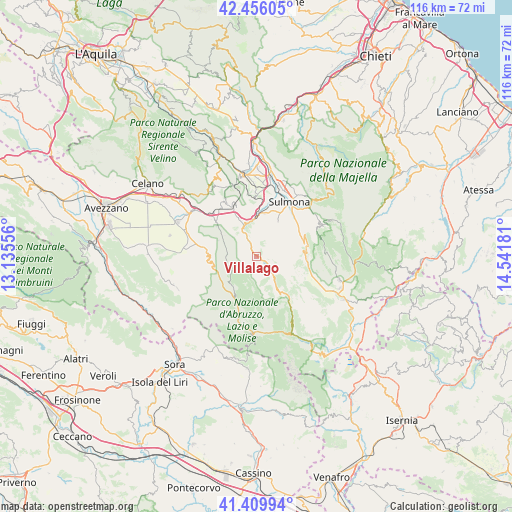
Villalago GPS coordinates[2]
41° 56' 6.504" North, 13° 50' 19.248" East
| Map corner | latitude | longitude |
|---|---|---|
| Upper-left | 42.45605°, | 13.13556° |
| Center: | 41.93514°, | 13.83868° |
| Lower-right: | 41.40994°, | 14.54181° |
| Map W x H: | 116.3×116.3 km | = 72.3×72.3mi |
| max Lat: | 47.04031° ⇑70.9% North |
| Villalago: | 41.93514° |
| min Lat: | ⇓29.1% South 35.50142° |
| min Long | Villalago | max Long |
| 6.69888° | 13.83868° | 18.48682° |
| W 77%⇐ | ⇒23% E |
Elevation
Elevation of Villalago is 917 m = 3009 ft, and this is 610.3 m = 2002 ft above average elevation for this country.
| Max E: |
2085 m = 6841 ft | 4.2% |
| Villalago | 917 m 3009 ft | |
| Avg. | 306.7 m = 1006 ft | |
Min E: |
-4 m = -13 ft | 95.8% |
See also: Italy elevation on elevation.city.
Geographical zone
Villalago is located in North temperate zone (between Tropic of Cancer and the Arctic Circle). Distance of this Northern Tropic circle is 2056.8 km =1278 mi to South.| Distance of | km | miles | from Villalago |
|---|---|---|---|
| North Pole | 5344.3 | 3320.8 | to North |
| Arctic Circle | 2738.4 | 1701.6 | to North |
| Tropic Cancer | 2056.8 | 1278 | to South |
| Equator | 4662.8 | 2897.3 | to South |


Nearby cities:
15 places around Villalago: (largest is in red/bold)
• Anversa degli Abruzzi
7.2 km =4.5 mi,  336°
336°
• Bisegna
6.9 km =4.3 mi,  256°
256°
• Bugnara
10 km =6.2 mi,  10°
10°
• Cocullo
12.1 km =7.5 mi,  334°
334°
• Gioia dei Marsi
12.5 km =7.8 mi,  281°
281°
• Introdacqua
9.6 km =6 mi,  30°
30°
• Lecce Nei Marsi
12.8 km =8 mi,  269°
269°
• Ortona dei Marsi
11.5 km =7.1 mi,  307°
307°
• Ortucchio
16 km =9.9 mi, 278°
• Pescasseroli
15.3 km =9.5 mi,  196°
196°
• Pettorano sul Gizio
10.9 km =6.8 mi,  67°
67°
• Prezza
13.7 km =8.5 mi,  359°
359°
• Rocca Pia
11.5 km =7.1 mi,  90°
90°
• Scanno
4.8 km =3 mi,  135°
135°
• Sulmona
14.6 km =9.1 mi, 29°
Sources, notices
• [Note1] Compared only with cities in Italy existing in our database
• [Src1] Map data: © OpenStreetMap contributors (CC-BY-SA)
• [Src2] Other city data from geonames.org with taken over terms of usage.
• [Src3] Geographical zone / Annual Mean Temperature by Robert A. Rohde @ Wikipedia
