Scanno geodata
Scanno (Abruzzo) is a seat of a third-order administrative division; located in Italy in Europe/Rome (GMT+2) time zone. With population of 1,900 people, there are 4316 cities with bigger population in this country. Compared to other cities in Italy, 71.2% of cities are located further ↑North; 77.3% of cities are located further ←West and 97% of cities have lower elevation than Scanno. Note1


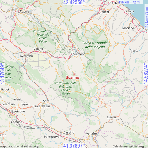
Scanno GPS coordinates[2]
41° 54' 15.912" North, 13° 52' 46.596" East
| Map corner | latitude | longitude |
|---|---|---|
| Upper-left | 42.42558°, | 13.17649° |
| Center: | 41.90442°, | 13.87961° |
| Lower-right: | 41.37897°, | 14.58274° |
| Map W x H: | 116.4×116.4 km | = 72.3×72.3mi |
| max Lat: | 47.04031° ⇑71.2% North |
| Scanno: | 41.90442° |
| min Lat: | ⇓28.8% South 35.50142° |
| min Long | Scanno | max Long |
| 6.69888° | 13.87961° | 18.48682° |
| W 77.3%⇐ | ⇒22.7% E |
Elevation
Elevation of Scanno is 997 m = 3271 ft, and this is 690.3 m = 2265 ft above average elevation for this country.
| Max E: |
2085 m = 6841 ft | 3% |
| Scanno | 997 m 3271 ft | |
| Avg. | 306.7 m = 1006 ft | |
Min E: |
-4 m = -13 ft | 97% |
See also: Italy elevation on elevation.city.
Geographical zone
Scanno is located in North temperate zone (between Tropic of Cancer and the Arctic Circle). Distance of this Northern Tropic circle is 2053.4 km =1275.9 mi to South.| Distance of | km | miles | from Scanno |
|---|---|---|---|
| North Pole | 5347.7 | 3322.9 | to North |
| Arctic Circle | 2741.8 | 1703.7 | to North |
| Tropic Cancer | 2053.4 | 1275.9 | to South |
| Equator | 4659.3 | 2895.2 | to South |


Nearby cities:
15 places around Scanno: (largest is in red/bold)
• Anversa degli Abruzzi
11.8 km =7.3 mi,  328°
328°
• Bisegna
10.3 km =6.4 mi,  280°
280°
• Bugnara
13.4 km =8.3 mi,  353°
353°
• Cansano
15.6 km =9.7 mi,  45°
45°
• Civitella Alfedena
16.3 km =10.1 mi,  161°
161°
• Introdacqua
11.8 km =7.3 mi,  7°
7°
• Opi
14.6 km =9.1 mi,  196°
196°
• Ortona dei Marsi
16.2 km =10.1 mi,  309°
309°
• Pescasseroli
13.6 km =8.5 mi,  214°
214°
• Pescocostanzo
15.6 km =9.7 mi,  97°
97°
• Pettorano sul Gizio
10.1 km =6.3 mi,  40°
40°
• Rivisondoli
15.9 km =9.9 mi, 103°
• Rocca Pia
8.7 km =5.4 mi,  67°
67°
• Villalago
4.8 km =3 mi,  315°
315°
• Villetta Barrea
15.1 km =9.4 mi, 160°
Sources, notices
• [Note1] Compared only with cities in Italy existing in our database
• [Src1] Map data: © OpenStreetMap contributors (CC-BY-SA)
• [Src2] Other city data from geonames.org with taken over terms of usage.
• [Src3] Geographical zone / Annual Mean Temperature by Robert A. Rohde @ Wikipedia
