Pescasseroli geodata
Pescasseroli (Abruzzo) is a seat of a third-order administrative division; located in Italy in Europe/Rome (GMT+2) time zone. With population of 2,224 people, there are 3838 cities with bigger population in this country. Compared to other cities in Italy, 72% of cities are located further ↑North; 76.5% of cities are located further ←West and 98.3% of cities have lower elevation than Pescasseroli. Note1


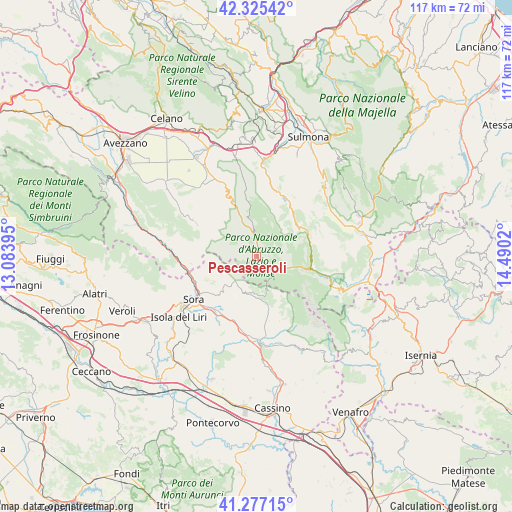
Pescasseroli GPS coordinates[2]
41° 48' 12.348" North, 13° 47' 13.452" East
| Map corner | latitude | longitude |
|---|---|---|
| Upper-left | 42.32542°, | 13.08395° |
| Center: | 41.80343°, | 13.78707° |
| Lower-right: | 41.27715°, | 14.4902° |
| Map W x H: | 116.6×116.6 km | = 72.5×72.5mi |
| max Lat: | 47.04031° ⇑72% North |
| Pescasseroli: | 41.80343° |
| min Lat: | ⇓28% South 35.50142° |
| min Long | Pescasseroli | max Long |
| 6.69888° | 13.78707° | 18.48682° |
| W 76.5%⇐ | ⇒23.5% E |
Elevation
Elevation of Pescasseroli is 1153 m = 3783 ft, and this is 846.3 m = 2777 ft above average elevation for this country.
| Max E: |
2085 m = 6841 ft | 1.7% |
| Pescasseroli | 1153 m 3783 ft | |
| Avg. | 306.7 m = 1006 ft | |
Min E: |
-4 m = -13 ft | 98.3% |
See also: Italy elevation on elevation.city.
Geographical zone
Pescasseroli is located in North temperate zone (between Tropic of Cancer and the Arctic Circle). Distance of this Northern Tropic circle is 2042.2 km =1269 mi to South.| Distance of | km | miles | from Pescasseroli |
|---|---|---|---|
| North Pole | 5359 | 3329.9 | to North |
| Arctic Circle | 2753.1 | 1710.7 | to North |
| Tropic Cancer | 2042.2 | 1269 | to South |
| Equator | 4648.1 | 2888.2 | to South |


Nearby cities:
15 places around Pescasseroli: (largest is in red/bold)
• Alvito
13 km =8.1 mi,  194°
194°
• Bisegna
13.3 km =8.3 mi,  349°
349°
• Campoli Appennino
11.5 km =7.1 mi,  228°
228°
• Civitella Alfedena
13.6 km =8.5 mi,  108°
108°
• Opi
4.5 km =2.8 mi,  128°
128°
• Pescosolido
12.4 km =7.7 mi,  240°
240°
• Posta Fibreno
15.2 km =9.4 mi,  215°
215°
• Ridotti
15.1 km =9.4 mi,  263°
263°
• San Donato Val di Comino
10.9 km =6.8 mi,  168°
168°
• Scanno
13.6 km =8.5 mi,  34°
34°
• Settefrati
15.7 km =9.8 mi,  160°
160°
• Vicalvi
15.4 km =9.6 mi,  205°
205°
• Villalago
15.3 km =9.5 mi,  16°
16°
• Villavallelonga
15.7 km =9.8 mi,  298°
298°
• Villetta Barrea
12.9 km =8 mi,  103°
103°
Sources, notices
• [Note1] Compared only with cities in Italy existing in our database
• [Src1] Map data: © OpenStreetMap contributors (CC-BY-SA)
• [Src2] Other city data from geonames.org with taken over terms of usage.
• [Src3] Geographical zone / Annual Mean Temperature by Robert A. Rohde @ Wikipedia
