Introdacqua geodata
Introdacqua (Abruzzo) is a seat of a third-order administrative division; located in Italy in Europe/Rome (GMT+2) time zone. With population of 939 people, there are 6928 cities with bigger population in this country. Compared to other cities in Italy, 70.2% of cities are located further ↑North; 77.5% of cities are located further ←West and 85.6% of cities have lower elevation than Introdacqua. Note1


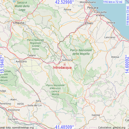
Introdacqua GPS coordinates[2]
42° 0' 34.848" North, 13° 53' 52.044" East
| Map corner | latitude | longitude |
|---|---|---|
| Upper-left | 42.52998°, | 13.19467° |
| Center: | 42.00968°, | 13.89779° |
| Lower-right: | 41.48509°, | 14.60092° |
| Map W x H: | 116.2×116.2 km | = 72.2×72.2mi |
| max Lat: | 47.04031° ⇑70.2% North |
| Introdacqua: | 42.00968° |
| min Lat: | ⇓29.8% South 35.50142° |
| min Long | Introdacqua | max Long |
| 6.69888° | 13.89779° | 18.48682° |
| W 77.5%⇐ | ⇒22.5% E |
Elevation
Elevation of Introdacqua is 624 m = 2047 ft, and this is 317.3 m = 1041 ft above average elevation for this country.
| Max E: |
2085 m = 6841 ft | 14.4% |
| Introdacqua | 624 m 2047 ft | |
| Avg. | 306.7 m = 1006 ft | |
Min E: |
-4 m = -13 ft | 85.6% |
See also: Italy elevation on elevation.city.
Geographical zone
Introdacqua is located in North temperate zone (between Tropic of Cancer and the Arctic Circle). Distance of this Northern Tropic circle is 2065.1 km =1283.2 mi to South.| Distance of | km | miles | from Introdacqua |
|---|---|---|---|
| North Pole | 5336 | 3315.6 | to North |
| Arctic Circle | 2730.1 | 1696.4 | to North |
| Tropic Cancer | 2065.1 | 1283.2 | to South |
| Equator | 4671 | 2902.4 | to South |


Nearby cities:
15 places around Introdacqua: (largest is in red/bold)
• Anversa degli Abruzzi
7.9 km =4.9 mi,  257°
257°
• Badia
9.1 km =5.7 mi,  10°
10°
• Bugnara
3.4 km =2.1 mi,  297°
297°
• Campo di Giove
11.7 km =7.3 mi,  89°
89°
• Cansano
9.6 km =6 mi, 94°
• Cocullo
10.5 km =6.5 mi,  284°
284°
• Marane
7.3 km =4.5 mi,  34°
34°
• Pacentro
9 km =5.6 mi,  59°
59°
• Pettorano sul Gizio
6.5 km =4 mi,  128°
128°
• Pratola Peligna
9.9 km =6.2 mi,  348°
348°
• Prezza
7.4 km =4.6 mi,  316°
316°
• Rocca Pia
10.7 km =6.6 mi,  141°
141°
• Scanno
11.8 km =7.3 mi,  187°
187°
• Sulmona
5 km =3.1 mi, 27°
• Villalago
9.6 km =6 mi,  210°
210°
Sources, notices
• [Note1] Compared only with cities in Italy existing in our database
• [Src1] Map data: © OpenStreetMap contributors (CC-BY-SA)
• [Src2] Other city data from geonames.org with taken over terms of usage.
• [Src3] Geographical zone / Annual Mean Temperature by Robert A. Rohde @ Wikipedia
