Viggiù geodata
Viggiù (Lombardy) is a seat of a third-order administrative division; located in Italy in Europe/Rome (GMT+2) time zone. With population of 3,091 people, there are 2971 cities with bigger population in this country. Compared to other cities in Italy, 88.3% of cities are located further ↓South; 82.6% of cities are located further →East and 77.7% of cities have lower elevation than Viggiù. Note1


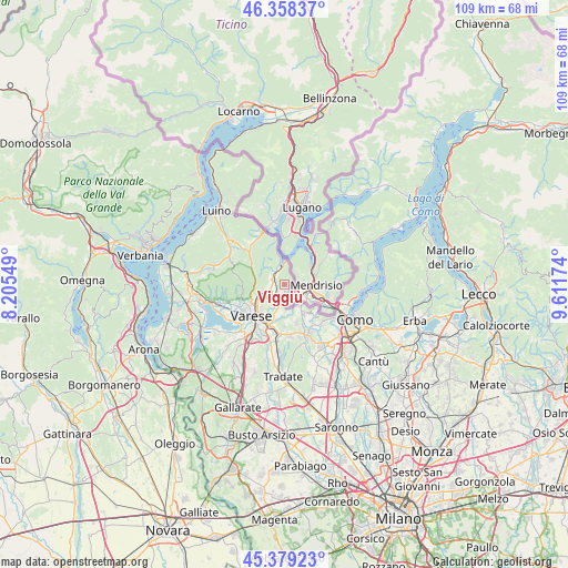
Viggiù GPS coordinates[2]
45° 52' 15.456" North, 8° 54' 30.996" East
| Map corner | latitude | longitude |
|---|---|---|
| Upper-left | 46.35837°, | 8.20549° |
| Center: | 45.87096°, | 8.90861° |
| Lower-right: | 45.37923°, | 9.61174° |
| Map W x H: | 108.9×108.9 km | = 67.7×67.7mi |
| max Lat: | 47.04031° ⇑11.7% North |
| Viggiù: | 45.87096° |
| min Lat: | ⇓88.3% South 35.50142° |
| min Long | Viggiù | max Long |
| 6.69888° | 8.90861° | 18.48682° |
| W 17.4%⇐ | ⇒82.6% E |
Elevation
Elevation of Viggiù is 489 m = 1604 ft, and this is 182.3 m = 598 ft above average elevation for this country.
| Max E: |
2085 m = 6841 ft | 22.3% |
| Viggiù | 489 m 1604 ft | |
| Avg. | 306.7 m = 1006 ft | |
Min E: |
-4 m = -13 ft | 77.7% |
See also: Italy elevation on elevation.city.
Geographical zone
Viggiù is located in North temperate zone (between Tropic of Cancer and the Arctic Circle). Distance of this North polar circle is 2300.8 km =1429.7 mi to North.| Distance of | km | miles | from Viggiù |
|---|---|---|---|
| North Pole | 4906.7 | 3048.9 | to North |
| Arctic Circle | 2300.8 | 1429.7 | to North |
| Tropic Cancer | 2494.5 | 1550 | to South |
| Equator | 5100.4 | 3169.2 | to South |


Nearby cities:
15 places around Viggiù: (largest is in red/bold)
• Arcisate
3.6 km =2.2 mi,  241°
241°
• Baraggia
1.8 km =1.1 mi,  179°
179°
• Besano
2.5 km =1.6 mi,  326°
326°
• Bisuschio
3.1 km =1.9 mi,  271°
271°
• Bizzarone
4.9 km =3 mi,  147°
147°
• Brenno Useria
2.6 km =1.6 mi,  246°
246°
• Cantello
5.5 km =3.4 mi,  190°
190°
• Cavagnano
4.8 km =3 mi,  322°
322°
• Clivio
1.9 km =1.2 mi,  117°
117°
• Cuasso al Monte
5.4 km =3.4 mi, 334°
• Cuasso al Piano
3.5 km =2.2 mi, 319°
• Gaggiolo
3.7 km =2.3 mi, 177°
• Porto Ceresio
4.7 km =2.9 mi,  348°
348°
• Rodero
5.2 km =3.2 mi,  174°
174°
• Saltrio
1.3 km =0.8 mi,  77°
77°
Sources, notices
• [Note1] Compared only with cities in Italy existing in our database
• [Src1] Map data: © OpenStreetMap contributors (CC-BY-SA)
• [Src2] Other city data from geonames.org with taken over terms of usage.
• [Src3] Geographical zone / Annual Mean Temperature by Robert A. Rohde @ Wikipedia
