Brenno Useria geodata
Brenno Useria (Lombardy) is a populated place; located in Italy in Europe/Rome (GMT+2) time zone. With population of 1,808 people, there are 4474 cities with bigger population in this country. Compared to other cities in Italy, 88% of cities are located further ↓South; 83.1% of cities are located further →East and 67.5% of cities have lower elevation than Brenno Useria. Note1


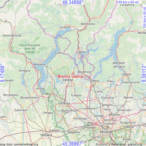
Brenno Useria GPS coordinates[2]
45° 51' 41.328" North, 8° 52' 40.836" East
| Map corner | latitude | longitude |
|---|---|---|
| Upper-left | 46.34898°, | 8.17488° |
| Center: | 45.86148°, | 8.87801° |
| Lower-right: | 45.36967°, | 9.58113° |
| Map W x H: | 108.9×108.9 km | = 67.7×67.7mi |
| max Lat: | 47.04031° ⇑12% North |
| Brenno Useria: | 45.86148° |
| min Lat: | ⇓88% South 35.50142° |
| min Long | Brenno Useria | max Long |
| 6.69888° | 8.87801° | 18.48682° |
| W 16.9%⇐ | ⇒83.1% E |
Elevation
Elevation of Brenno Useria is 368 m = 1207 ft, and this is 61.3 m = 201 ft above average elevation for this country.
| Max E: |
2085 m = 6841 ft | 32.5% |
| Brenno Useria | 368 m 1207 ft | |
| Avg. | 306.7 m = 1006 ft | |
Min E: |
-4 m = -13 ft | 67.5% |
See also: Italy elevation on elevation.city.
Geographical zone
Brenno Useria is located in North temperate zone (between Tropic of Cancer and the Arctic Circle). Distance of this North polar circle is 2301.9 km =1430.3 mi to North.| Distance of | km | miles | from Brenno Useria |
|---|---|---|---|
| North Pole | 4907.7 | 3049.5 | to North |
| Arctic Circle | 2301.9 | 1430.3 | to North |
| Tropic Cancer | 2493.4 | 1549.3 | to South |
| Equator | 5099.3 | 3168.6 | to South |


Nearby cities:
15 places around Brenno Useria: (largest is in red/bold)
• Arcisate
1 km =0.6 mi,  230°
230°
• Baraggia
2.5 km =1.6 mi,  106°
106°
• Besano
3.3 km =2.1 mi,  17°
17°
• Bisuschio
1.3 km =0.8 mi,  326°
326°
• Cantello
4.6 km =2.9 mi,  162°
162°
• Cavagnano
4.9 km =3 mi,  353°
353°
• Clivio
4.1 km =2.5 mi,  87°
87°
• Cuasso al Monte
5.9 km =3.7 mi,  0°
0°
• Cuasso al Piano
3.7 km =2.3 mi, 1°
• Gaggiolo
3.6 km =2.2 mi,  136°
136°
• Induno Olona
3.4 km =2.1 mi,  238°
238°
• Porto Ceresio
5.9 km =3.7 mi,  14°
14°
• Rodero
5.1 km =3.2 mi,  145°
145°
• Saltrio
3.8 km =2.4 mi,  69°
69°
• Viggiù
2.6 km =1.6 mi, 66°
Sources, notices
• [Note1] Compared only with cities in Italy existing in our database
• [Src1] Map data: © OpenStreetMap contributors (CC-BY-SA)
• [Src2] Other city data from geonames.org with taken over terms of usage.
• [Src3] Geographical zone / Annual Mean Temperature by Robert A. Rohde @ Wikipedia
