Viareggio geodata
Viareggio (Tuscany) is a seat of a third-order administrative division; located in Italy in Europe/Rome (GMT+2) time zone. With population of 49,099 people, there are 120 cities with bigger population in this country. Compared to other cities in Italy, 56.1% of cities are located further ↑North; 65.5% of cities are located further →East and 97.8% of cities have higher elevation than Viareggio. Note1


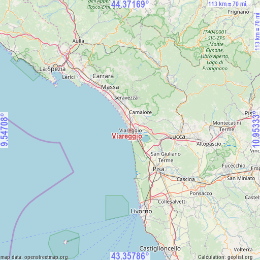
Viareggio GPS coordinates[2]
43° 52' 0.948" North, 10° 15' 0.72" East
| Map corner | latitude | longitude |
|---|---|---|
| Upper-left | 44.37169°, | 9.54708° |
| Center: | 43.86693°, | 10.2502° |
| Lower-right: | 43.35786°, | 10.95333° |
| Map W x H: | 112.7×112.7 km | = 70×70mi |
| max Lat: | 47.04031° ⇑56.1% North |
| Viareggio: | 43.86693° |
| min Lat: | ⇓43.9% South 35.50142° |
| min Long | Viareggio | max Long |
| 6.69888° | 10.2502° | 18.48682° |
| W 34.5%⇐ | ⇒65.5% E |
Elevation
Elevation of Viareggio is 4 m = 13 ft, and this is 302.7 m = 993 ft below average elevation for this country.
| Max E: |
2085 m = 6841 ft | 97.8% |
| Avg. | 306.7 m = 1006 ft | |
| Viareggio | 4 m = 13 ft | |
Min E: |
-4 m = -13 ft | 2.2% |
See also: Viareggio elevation on elevation.city.
Geographical zone
Viareggio is located in North temperate zone (between Tropic of Cancer and the Arctic Circle). Distance of this Northern Tropic circle is 2271.6 km =1411.5 mi to South.| Distance of | km | miles | from Viareggio |
|---|---|---|---|
| North Pole | 5129.5 | 3187.3 | to North |
| Arctic Circle | 2523.6 | 1568.1 | to North |
| Tropic Cancer | 2271.6 | 1411.5 | to South |
| Equator | 4877.5 | 3030.7 | to South |


Nearby cities:
15 places around Viareggio: (largest is in red/bold)
• Camaiore
9.2 km =5.7 mi,  24°
24°
• Corsanico-Bargecchia
6.4 km =4 mi,  44°
44°
• Filettole
13.6 km =8.5 mi,  116°
116°
• Forte dei Marmi
12.4 km =7.7 mi,  330°
330°
• Massarosa
7.6 km =4.7 mi,  90°
90°
• Metato
14.2 km =8.8 mi,  136°
136°
• Migliarino
13.3 km =8.3 mi,  147°
147°
• Nocchi
9.7 km =6 mi,  51°
51°
• Piano di Conca
4.7 km =2.9 mi, 49°
• Piano di Mommio
5.1 km =3.2 mi, 22°
• Pietrasanta
10.4 km =6.5 mi,  350°
350°
• Ripa-Pozzi-Querceta-Ponterosso
12.9 km =8 mi,  343°
343°
• Stiava
6.4 km =4 mi,  58°
58°
• Torre del Lago Puccini
5.3 km =3.3 mi, 143°
• Vecchiano-Nodica
14.2 km =8.8 mi,  130°
130°
Sources, notices
• [Note1] Compared only with cities in Italy existing in our database
• [Src1] Map data: © OpenStreetMap contributors (CC-BY-SA)
• [Src2] Other city data from geonames.org with taken over terms of usage.
• [Src3] Geographical zone / Annual Mean Temperature by Robert A. Rohde @ Wikipedia
