Stiava geodata
Stiava (Tuscany) is a populated locality; located in Italy in Europe/Rome (GMT+2) time zone. With population of 3,109 people, there are 2952 cities with bigger population in this country. Compared to other cities in Italy, 55.7% of cities are located further ↑North; 64.8% of cities are located further →East and 91.5% of cities have higher elevation than Stiava. Note1


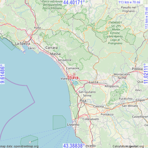
Stiava GPS coordinates[2]
43° 53' 49.92" North, 10° 19' 4.728" East
| Map corner | latitude | longitude |
|---|---|---|
| Upper-left | 44.40171°, | 9.61486° |
| Center: | 43.8972°, | 10.31798° |
| Lower-right: | 43.38838°, | 11.02111° |
| Map W x H: | 112.7×112.7 km | = 70×70mi |
| max Lat: | 47.04031° ⇑55.7% North |
| Stiava: | 43.8972° |
| min Lat: | ⇓44.3% South 35.50142° |
| min Long | Stiava | max Long |
| 6.69888° | 10.31798° | 18.48682° |
| W 35.2%⇐ | ⇒64.8% E |
Elevation
Elevation of Stiava is 15 m = 49 ft, and this is 291.7 m = 957 ft below average elevation for this country.
| Max E: |
2085 m = 6841 ft | 91.5% |
| Avg. | 306.7 m = 1006 ft | |
| Stiava | 15 m = 49 ft | |
Min E: |
-4 m = -13 ft | 8.5% |
See also: Italy elevation on elevation.city.
Geographical zone
Stiava is located in North temperate zone (between Tropic of Cancer and the Arctic Circle). Distance of this Northern Tropic circle is 2275 km =1413.6 mi to South.| Distance of | km | miles | from Stiava |
|---|---|---|---|
| North Pole | 5126.2 | 3185.3 | to North |
| Arctic Circle | 2520.3 | 1566 | to North |
| Tropic Cancer | 2275 | 1413.6 | to South |
| Equator | 4880.9 | 3032.8 | to South |


Nearby cities:
15 places around Stiava: (largest is in red/bold)
• Camaiore
5.3 km =3.3 mi,  342°
342°
• Corsanico-Bargecchia
1.6 km =1 mi,  322°
322°
• Filettole
11.5 km =7.1 mi,  144°
144°
• Massarosa
4 km =2.5 mi,  148°
148°
• Nocchi
3.4 km =2.1 mi,  39°
39°
• Pescaglia
10.7 km =6.6 mi,  45°
45°
• Piano di Conca
1.9 km =1.2 mi,  259°
259°
• Piano di Mommio
3.8 km =2.4 mi,  291°
291°
• Pietrasanta
10 km =6.2 mi,  313°
313°
• Pontestazzemese
11.2 km =7 mi,  350°
350°
• Ripa-Pozzi-Querceta-Ponterosso
12.8 km =8 mi, 314°
• Ripafratta-Farneta
11.9 km =7.4 mi, 138°
• San Martino in Freddana-Monsagrati
9.7 km =6 mi,  82°
82°
• Torre del Lago Puccini
7.9 km =4.9 mi,  196°
196°
• Viareggio
6.4 km =4 mi,  238°
238°
Sources, notices
• [Note1] Compared only with cities in Italy existing in our database
• [Src1] Map data: © OpenStreetMap contributors (CC-BY-SA)
• [Src2] Other city data from geonames.org with taken over terms of usage.
• [Src3] Geographical zone / Annual Mean Temperature by Robert A. Rohde @ Wikipedia
