Camaiore geodata
Camaiore (Tuscany) is a seat of a third-order administrative division; located in Italy in Europe/Rome (GMT+2) time zone. With population of 26,746 people, there are 299 cities with bigger population in this country. Compared to other cities in Italy, 55.2% of cities are located further ↑North; 65% of cities are located further →East and 83.4% of cities have higher elevation than Camaiore. Note1


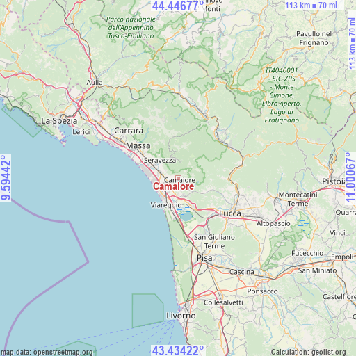
Camaiore GPS coordinates[2]
43° 56' 33.54" North, 10° 17' 51.144" East
| Map corner | latitude | longitude |
|---|---|---|
| Upper-left | 44.44677°, | 9.59442° |
| Center: | 43.94265°, | 10.29754° |
| Lower-right: | 43.43422°, | 11.00067° |
| Map W x H: | 112.6×112.6 km | = 70×70mi |
| max Lat: | 47.04031° ⇑55.2% North |
| Camaiore: | 43.94265° |
| min Lat: | ⇓44.8% South 35.50142° |
| min Long | Camaiore | max Long |
| 6.69888° | 10.29754° | 18.48682° |
| W 35%⇐ | ⇒65% E |
Elevation
Elevation of Camaiore is 36 m = 118 ft, and this is 270.7 m = 888 ft below average elevation for this country.
| Max E: |
2085 m = 6841 ft | 83.4% |
| Avg. | 306.7 m = 1006 ft | |
| Camaiore | 36 m = 118 ft | |
Min E: |
-4 m = -13 ft | 16.6% |
See also: Italy elevation on elevation.city.
Geographical zone
Camaiore is located in North temperate zone (between Tropic of Cancer and the Arctic Circle). Distance of this Northern Tropic circle is 2280 km =1416.7 mi to South.| Distance of | km | miles | from Camaiore |
|---|---|---|---|
| North Pole | 5121.1 | 3182.1 | to North |
| Arctic Circle | 2515.2 | 1562.9 | to North |
| Tropic Cancer | 2280 | 1416.7 | to South |
| Equator | 4886 | 3036 | to South |


Nearby cities:
15 places around Camaiore: (largest is in red/bold)
• Corsanico-Bargecchia
3.9 km =2.4 mi,  169°
169°
• Forte dei Marmi
10.1 km =6.3 mi,  283°
283°
• Massarosa
9.3 km =5.8 mi,  156°
156°
• Nocchi
4.5 km =2.8 mi,  122°
122°
• Pescaglia
9.6 km =6 mi,  74°
74°
• Piano di Conca
5.4 km =3.4 mi,  182°
182°
• Piano di Mommio
4.1 km =2.5 mi,  206°
206°
• Pietrasanta
5.9 km =3.7 mi,  288°
288°
• Pontestazzemese
6 km =3.7 mi,  357°
357°
• Ripa-Pozzi-Querceta-Ponterosso
8.5 km =5.3 mi,  297°
297°
• San Martino in Freddana-Monsagrati
11.8 km =7.3 mi,  108°
108°
• Seravezza
8.1 km =5 mi,  315°
315°
• Stiava
5.3 km =3.3 mi, 162°
• Strettoia
9.8 km =6.1 mi, 302°
• Viareggio
9.2 km =5.7 mi,  204°
204°
Sources, notices
• [Note1] Compared only with cities in Italy existing in our database
• [Src1] Map data: © OpenStreetMap contributors (CC-BY-SA)
• [Src2] Other city data from geonames.org with taken over terms of usage.
• [Src3] Geographical zone / Annual Mean Temperature by Robert A. Rohde @ Wikipedia
