Ventimiglia geodata
Ventimiglia (Liguria) is a seat of a third-order administrative division; located in Italy in Europe/Rome (GMT+2) time zone. With population of 18,442 people, there are 477 cities with bigger population in this country. Compared to other cities in Italy, 57.1% of cities are located further ↑North; 97% of cities are located further →East and 94.1% of cities have higher elevation than Ventimiglia. Note1


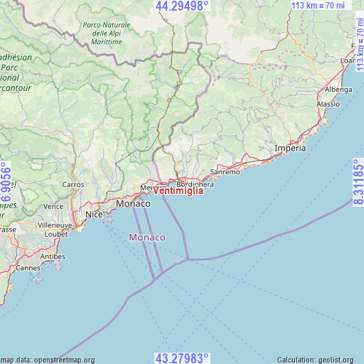
Ventimiglia GPS coordinates[2]
43° 47' 22.416" North, 7° 36' 31.392" East
| Map corner | latitude | longitude |
|---|---|---|
| Upper-left | 44.29498°, | 6.9056° |
| Center: | 43.78956°, | 7.60872° |
| Lower-right: | 43.27983°, | 8.31185° |
| Map W x H: | 112.9×112.9 km | = 70.2×70.2mi |
| max Lat: | 47.04031° ⇑57.1% North |
| Ventimiglia: | 43.78956° |
| min Lat: | ⇓42.9% South 35.50142° |
| min Long | Ventimiglia | max Long |
| 6.69888° | 7.60872° | 18.48682° |
| W 3%⇐ | ⇒97% E |
Elevation
Elevation of Ventimiglia is 10 m = 33 ft, and this is 296.7 m = 973 ft below average elevation for this country.
| Max E: |
2085 m = 6841 ft | 94.1% |
| Avg. | 306.7 m = 1006 ft | |
| Ventimiglia | 10 m = 33 ft | |
Min E: |
-4 m = -13 ft | 5.9% |
See also: Italy elevation on elevation.city.
Geographical zone
Ventimiglia is located in North temperate zone (between Tropic of Cancer and the Arctic Circle). Distance of this Northern Tropic circle is 2263 km =1406.2 mi to South.| Distance of | km | miles | from Ventimiglia |
|---|---|---|---|
| North Pole | 5138.1 | 3192.7 | to North |
| Arctic Circle | 2532.2 | 1573.4 | to North |
| Tropic Cancer | 2263 | 1406.2 | to South |
| Equator | 4868.9 | 3025.4 | to South |


Nearby cities:
15 places around Ventimiglia: (largest is in red/bold)
• Airole
10.1 km =6.3 mi,  334°
334°
• Apricale
10.9 km =6.8 mi,  22°
22°
• Bordighera
4.6 km =2.9 mi,  102°
102°
• Camporosso
3.1 km =1.9 mi,  30°
30°
• Dolceacqua
6.8 km =4.2 mi,  10°
10°
• Isolabona
10.4 km =6.5 mi, 13°
• Latte
3.5 km =2.2 mi,  278°
278°
• Ospedaletti
8.9 km =5.5 mi,  80°
80°
• Perinaldo
10 km =6.2 mi, 30°
• Rocchetta Nervina
11.2 km =7 mi,  356°
356°
• San Biagio della Cima
4.6 km =2.9 mi,  47°
47°
• Seborga
8.2 km =5.1 mi,  59°
59°
• Soldano
5.9 km =3.7 mi,  40°
40°
• Vallebona
5.2 km =3.2 mi, 61°
• Vallecrosia
2.5 km =1.6 mi, 97°
Sources, notices
• [Note1] Compared only with cities in Italy existing in our database
• [Src1] Map data: © OpenStreetMap contributors (CC-BY-SA)
• [Src2] Other city data from geonames.org with taken over terms of usage.
• [Src3] Geographical zone / Annual Mean Temperature by Robert A. Rohde @ Wikipedia
