Perinaldo geodata
Perinaldo (Liguria) is a seat of a third-order administrative division; located in Italy in Europe/Rome (GMT+2) time zone. With population of 545 people, there are 9497 cities with bigger population in this country. Compared to other cities in Italy, 56.1% of cities are located further ↑North; 96.5% of cities are located further →East and 80.7% of cities have lower elevation than Perinaldo. Note1


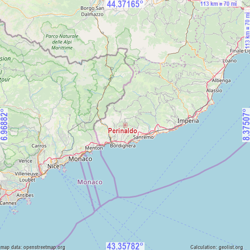
Perinaldo GPS coordinates[2]
43° 52' 0.804" North, 7° 40' 18.984" East
| Map corner | latitude | longitude |
|---|---|---|
| Upper-left | 44.37165°, | 6.96882° |
| Center: | 43.86689°, | 7.67194° |
| Lower-right: | 43.35782°, | 8.37507° |
| Map W x H: | 112.7×112.7 km | = 70×70mi |
| max Lat: | 47.04031° ⇑56.1% North |
| Perinaldo: | 43.86689° |
| min Lat: | ⇓43.9% South 35.50142° |
| min Long | Perinaldo | max Long |
| 6.69888° | 7.67194° | 18.48682° |
| W 3.5%⇐ | ⇒96.5% E |
Elevation
Elevation of Perinaldo is 535 m = 1755 ft, and this is 228.3 m = 749 ft above average elevation for this country.
| Max E: |
2085 m = 6841 ft | 19.3% |
| Perinaldo | 535 m 1755 ft | |
| Avg. | 306.7 m = 1006 ft | |
Min E: |
-4 m = -13 ft | 80.7% |
See also: Italy elevation on elevation.city.
Geographical zone
Perinaldo is located in North temperate zone (between Tropic of Cancer and the Arctic Circle). Distance of this Northern Tropic circle is 2271.6 km =1411.5 mi to South.| Distance of | km | miles | from Perinaldo |
|---|---|---|---|
| North Pole | 5129.5 | 3187.3 | to North |
| Arctic Circle | 2523.6 | 1568.1 | to North |
| Tropic Cancer | 2271.6 | 1411.5 | to South |
| Equator | 4877.5 | 3030.7 | to South |


Nearby cities:
15 places around Perinaldo: (largest is in red/bold)
• Apricale
1.8 km =1.1 mi,  327°
327°
• Bajardo
5.9 km =3.7 mi,  46°
46°
• Camporosso
6.9 km =4.3 mi,  210°
210°
• Castel Vittorio
6.7 km =4.2 mi,  1°
1°
• Ceriana
8.4 km =5.2 mi,  79°
79°
• Dolceacqua
4.3 km =2.7 mi,  243°
243°
• Isolabona
3 km =1.9 mi,  301°
301°
• Ospedaletti
8.1 km =5 mi,  152°
152°
• Pigna
7.3 km =4.5 mi,  353°
353°
• Rocchetta Nervina
6.3 km =3.9 mi,  294°
294°
• San Biagio della Cima
5.7 km =3.5 mi,  196°
196°
• Seborga
4.8 km =3 mi,  156°
156°
• Soldano
4.3 km =2.7 mi, 196°
• Vallebona
6.1 km =3.8 mi,  184°
184°
• Vallecrosia
9.3 km =5.8 mi, 196°
Sources, notices
• [Note1] Compared only with cities in Italy existing in our database
• [Src1] Map data: © OpenStreetMap contributors (CC-BY-SA)
• [Src2] Other city data from geonames.org with taken over terms of usage.
• [Src3] Geographical zone / Annual Mean Temperature by Robert A. Rohde @ Wikipedia
