Vallebona geodata
Vallebona (Liguria) is a seat of a third-order administrative division; located in Italy in Europe/Rome (GMT+2) time zone. With population of 779 people, there are 7764 cities with bigger population in this country. Compared to other cities in Italy, 56.9% of cities are located further ↑North; 96.5% of cities are located further →East and 56.8% of cities have higher elevation than Vallebona. Note1


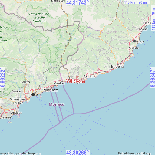
Vallebona GPS coordinates[2]
43° 48' 43.92" North, 7° 39' 55.26" East
| Map corner | latitude | longitude |
|---|---|---|
| Upper-left | 44.31743°, | 6.96222° |
| Center: | 43.8122°, | 7.66535° |
| Lower-right: | 43.30266°, | 8.36847° |
| Map W x H: | 112.8×112.8 km | = 70.1×70.1mi |
| max Lat: | 47.04031° ⇑56.9% North |
| Vallebona: | 43.8122° |
| min Lat: | ⇓43.1% South 35.50142° |
| min Long | Vallebona | max Long |
| 6.69888° | 7.66535° | 18.48682° |
| W 3.5%⇐ | ⇒96.5% E |
Elevation
Elevation of Vallebona is 189 m = 620 ft, and this is 117.7 m = 386 ft below average elevation for this country.
| Max E: |
2085 m = 6841 ft | 56.8% |
| Avg. | 306.7 m = 1006 ft | |
| Vallebona | 189 m = 620 ft | |
Min E: |
-4 m = -13 ft | 43.2% |
See also: Italy elevation on elevation.city.
Geographical zone
Vallebona is located in North temperate zone (between Tropic of Cancer and the Arctic Circle). Distance of this Northern Tropic circle is 2265.5 km =1407.7 mi to South.| Distance of | km | miles | from Vallebona |
|---|---|---|---|
| North Pole | 5135.6 | 3191.1 | to North |
| Arctic Circle | 2529.7 | 1571.9 | to North |
| Tropic Cancer | 2265.5 | 1407.7 | to South |
| Equator | 4871.5 | 3027 | to South |


Nearby cities:
15 places around Vallebona: (largest is in red/bold)
• Apricale
7.6 km =4.7 mi,  356°
356°
• Bordighera
3.5 km =2.2 mi,  181°
181°
• Camporosso
3 km =1.9 mi,  271°
271°
• Dolceacqua
5.3 km =3.3 mi,  321°
321°
• Isolabona
7.9 km =4.9 mi,  345°
345°
• Latte
8.2 km =5.1 mi,  255°
255°
• Ospedaletti
4.4 km =2.7 mi,  104°
104°
• Perinaldo
6.1 km =3.8 mi,  4°
4°
• Rocchetta Nervina
10.1 km =6.3 mi,  329°
329°
• San Biagio della Cima
1.3 km =0.8 mi,  299°
299°
• San Remo
9 km =5.6 mi,  86°
86°
• Seborga
3 km =1.9 mi,  55°
55°
• Soldano
2.1 km =1.3 mi,  339°
339°
• Vallecrosia
3.5 km =2.2 mi,  216°
216°
• Ventimiglia
5.2 km =3.2 mi,  241°
241°
Sources, notices
• [Note1] Compared only with cities in Italy existing in our database
• [Src1] Map data: © OpenStreetMap contributors (CC-BY-SA)
• [Src2] Other city data from geonames.org with taken over terms of usage.
• [Src3] Geographical zone / Annual Mean Temperature by Robert A. Rohde @ Wikipedia
