Venafro geodata
Venafro (Molise) is a seat of a third-order administrative division; located in Italy in Europe/Rome (GMT+2) time zone. With population of 9,384 people, there are 1003 cities with bigger population in this country. Compared to other cities in Italy, 75% of cities are located further ↑North; 78.5% of cities are located further ←West and 58.2% of cities have higher elevation than Venafro. Note1


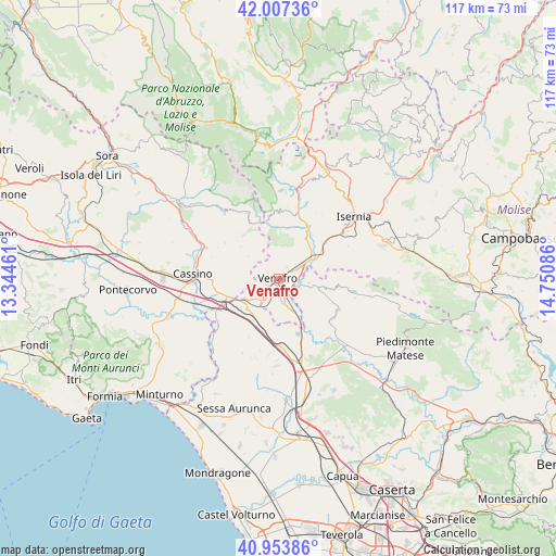
Venafro GPS coordinates[2]
41° 28' 57.9" North, 14° 2' 51.828" East
| Map corner | latitude | longitude |
|---|---|---|
| Upper-left | 42.00736°, | 13.34461° |
| Center: | 41.48275°, | 14.04773° |
| Lower-right: | 40.95386°, | 14.75086° |
| Map W x H: | 117.1×117.1 km | = 72.8×72.8mi |
| max Lat: | 47.04031° ⇑75% North |
| Venafro: | 41.48275° |
| min Lat: | ⇓25% South 35.50142° |
| min Long | Venafro | max Long |
| 6.69888° | 14.04773° | 18.48682° |
| W 78.5%⇐ | ⇒21.5% E |
Elevation
Elevation of Venafro is 178 m = 584 ft, and this is 128.7 m = 422 ft below average elevation for this country.
| Max E: |
2085 m = 6841 ft | 58.2% |
| Avg. | 306.7 m = 1006 ft | |
| Venafro | 178 m = 584 ft | |
Min E: |
-4 m = -13 ft | 41.8% |
See also: Italy elevation on elevation.city.
Geographical zone
Venafro is located in North temperate zone (between Tropic of Cancer and the Arctic Circle). Distance of this Northern Tropic circle is 2006.5 km =1246.8 mi to South.| Distance of | km | miles | from Venafro |
|---|---|---|---|
| North Pole | 5394.6 | 3352 | to North |
| Arctic Circle | 2788.7 | 1732.8 | to North |
| Tropic Cancer | 2006.5 | 1246.8 | to South |
| Equator | 4612.4 | 2866 | to South |


Nearby cities:
15 places around Venafro: (largest is in red/bold)
• Campopino
5.8 km =3.6 mi,  167°
167°
• Capriati A Volturno
8.4 km =5.2 mi,  101°
101°
• Ceppagna
3.5 km =2.2 mi,  230°
230°
• Ciorlano
9.9 km =6.2 mi,  111°
111°
• Conca Casale
3.7 km =2.3 mi,  291°
291°
• Filignano
7.1 km =4.4 mi,  6°
6°
• Mignano Monte Lungo
10 km =6.2 mi,  211°
211°
• Pozzilli
3.4 km =2.1 mi,  21°
21°
• San Pietro Infine
8.4 km =5.2 mi,  240°
240°
• San Vittore del Lazio
9.8 km =6.1 mi,  256°
256°
• Sant'Eusanio
10 km =6.2 mi,  58°
58°
• Selvotta
7.8 km =4.8 mi,  154°
154°
• Sesto Campano
7.4 km =4.6 mi,  160°
160°
• Taverna Ravindola
7.9 km =4.9 mi, 55°
• Viticuso
8 km =5 mi,  305°
305°
Sources, notices
• [Note1] Compared only with cities in Italy existing in our database
• [Src1] Map data: © OpenStreetMap contributors (CC-BY-SA)
• [Src2] Other city data from geonames.org with taken over terms of usage.
• [Src3] Geographical zone / Annual Mean Temperature by Robert A. Rohde @ Wikipedia
