Selvotta geodata
Selvotta (Molise) is a populated place; located in Italy in Europe/Rome (GMT+2) time zone. With population of 662 people, there are 8548 cities with bigger population in this country. Compared to other cities in Italy, 75.4% of cities are located further ↑North; 78.9% of cities are located further ←West and 60.7% of cities have higher elevation than Selvotta. Note1


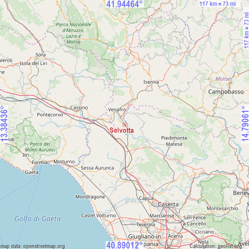
Selvotta GPS coordinates[2]
41° 25' 10.272" North, 14° 5' 14.928" East
| Map corner | latitude | longitude |
|---|---|---|
| Upper-left | 41.94464°, | 13.38436° |
| Center: | 41.41952°, | 14.08748° |
| Lower-right: | 40.89012°, | 14.79061° |
| Map W x H: | 117.3×117.3 km | = 72.9×72.9mi |
| max Lat: | 47.04031° ⇑75.4% North |
| Selvotta: | 41.41952° |
| min Lat: | ⇓24.6% South 35.50142° |
| min Long | Selvotta | max Long |
| 6.69888° | 14.08748° | 18.48682° |
| W 78.9%⇐ | ⇒21.1% E |
Elevation
Elevation of Selvotta is 158 m = 518 ft, and this is 148.7 m = 488 ft below average elevation for this country.
| Max E: |
2085 m = 6841 ft | 60.7% |
| Avg. | 306.7 m = 1006 ft | |
| Selvotta | 158 m = 518 ft | |
Min E: |
-4 m = -13 ft | 39.3% |
See also: Italy elevation on elevation.city.
Geographical zone
Selvotta is located in North temperate zone (between Tropic of Cancer and the Arctic Circle). Distance of this Northern Tropic circle is 1999.5 km =1242.4 mi to South.| Distance of | km | miles | from Selvotta |
|---|---|---|---|
| North Pole | 5401.6 | 3356.4 | to North |
| Arctic Circle | 2795.8 | 1737.2 | to North |
| Tropic Cancer | 1999.5 | 1242.4 | to South |
| Equator | 4605.4 | 2861.7 | to South |


Nearby cities:
15 places around Selvotta: (largest is in red/bold)
• Ailano
10.4 km =6.5 mi,  108°
108°
• Campopino
2.4 km =1.5 mi,  304°
304°
• Capriati A Volturno
7.3 km =4.5 mi,  42°
42°
• Ceppagna
7.7 km =4.8 mi,  308°
308°
• Ciorlano
6.8 km =4.2 mi,  59°
59°
• Fontegreca
9 km =5.6 mi, 62°
• Mignano Monte Lungo
8.6 km =5.3 mi,  259°
259°
• Pozzilli
10.4 km =6.5 mi,  348°
348°
• Prata Sannita Centro
9.7 km =6 mi,  81°
81°
• Pratella
7.8 km =4.8 mi,  101°
101°
• Presenzano
4.6 km =2.9 mi,  175°
175°
• Sesto Campano
0.8 km =0.5 mi,  277°
277°
• Tora
10.3 km =6.4 mi,  210°
210°
• Vairano-Patenora
9.9 km =6.2 mi,  158°
158°
• Venafro
7.8 km =4.8 mi,  334°
334°
Sources, notices
• [Note1] Compared only with cities in Italy existing in our database
• [Src1] Map data: © OpenStreetMap contributors (CC-BY-SA)
• [Src2] Other city data from geonames.org with taken over terms of usage.
• [Src3] Geographical zone / Annual Mean Temperature by Robert A. Rohde @ Wikipedia
