Foza geodata
Foza (Veneto) is a seat of a third-order administrative division; located in Italy in Europe/Rome (GMT+2) time zone. With population of 293 people, there are 10701 cities with bigger population in this country. Compared to other cities in Italy, 89.1% of cities are located further ↓South; 51% of cities are located further ←West and 98% of cities have lower elevation than Foza. Note1


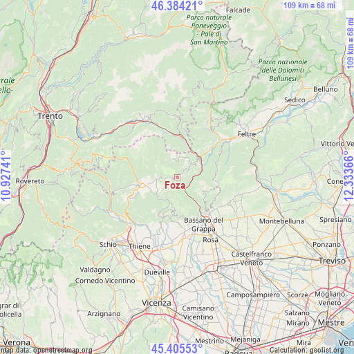
Foza GPS coordinates[2]
45° 53' 49.308" North, 11° 37' 49.908" East
| Map corner | latitude | longitude |
|---|---|---|
| Upper-left | 46.38421°, | 10.92741° |
| Center: | 45.89703°, | 11.63053° |
| Lower-right: | 45.40553°, | 12.33366° |
| Map W x H: | 108.8×108.8 km | = 67.6×67.6mi |
| max Lat: | 47.04031° ⇑10.9% North |
| Foza: | 45.89703° |
| min Lat: | ⇓89.1% South 35.50142° |
| min Long | Foza | max Long |
| 6.69888° | 11.63053° | 18.48682° |
| W 51%⇐ | ⇒49% E |
Elevation
Elevation of Foza is 1084 m = 3556 ft, and this is 777.3 m = 2550 ft above average elevation for this country.
| Max E: |
2085 m = 6841 ft | 2% |
| Foza | 1084 m 3556 ft | |
| Avg. | 306.7 m = 1006 ft | |
Min E: |
-4 m = -13 ft | 98% |
See also: Italy elevation on elevation.city.
Geographical zone
Foza is located in North temperate zone (between Tropic of Cancer and the Arctic Circle). Distance of this North polar circle is 2297.9 km =1427.8 mi to North.| Distance of | km | miles | from Foza |
|---|---|---|---|
| North Pole | 4903.8 | 3047.1 | to North |
| Arctic Circle | 2297.9 | 1427.8 | to North |
| Tropic Cancer | 2497.4 | 1551.8 | to South |
| Equator | 5103.3 | 3171 | to South |


Nearby cities:
15 places around Foza: (largest is in red/bold)
• Asiago
9.5 km =5.9 mi,  255°
255°
• Campese
12 km =7.5 mi,  147°
147°
• Campolongo sul Brenta
9.5 km =5.9 mi, 145°
• Canove di Roana
12.7 km =7.9 mi,  252°
252°
• Cismon del Grappa
8 km =5 mi,  71°
71°
• Conco
10.9 km =6.8 mi,  188°
188°
• Enego
7.6 km =4.7 mi,  49°
49°
• Gallio
7.6 km =4.7 mi, 259°
• Grigno
13.2 km =8.2 mi,  1°
1°
• Rodeghieri-Rigoni-Podestà-Costa
9 km =5.6 mi, 264°
• San Nazario
7.8 km =4.8 mi,  144°
144°
• Solagna
11 km =6.8 mi, 141°
• Tezze
10.9 km =6.8 mi,  16°
16°
• Valrovina
13 km =8.1 mi,  159°
159°
• Valstagna
5.8 km =3.6 mi, 151°
Sources, notices
• [Note1] Compared only with cities in Italy existing in our database
• [Src1] Map data: © OpenStreetMap contributors (CC-BY-SA)
• [Src2] Other city data from geonames.org with taken over terms of usage.
• [Src3] Geographical zone / Annual Mean Temperature by Robert A. Rohde @ Wikipedia
