Oliveto Lucano geodata
Oliveto Lucano (Basilicate) is a seat of a third-order administrative division; located in Italy in Europe/Rome (GMT+2) time zone. With population of 473 people, there are 10010 cities with bigger population in this country. Compared to other cities in Italy, 83.9% of cities are located further ↑North; 94.3% of cities are located further ←West and 81.3% of cities have lower elevation than Oliveto Lucano. Note1
Administrative division(s):
- Level 1: Basilicate
- Level 2: Provincia di Matera
- Level 3: Oliveto Lucano


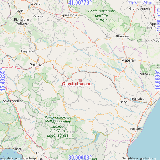
Oliveto Lucano GPS coordinates[2]
40° 32' 7.944" North, 16° 11' 7.692" East
| Map corner | latitude | longitude |
|---|---|---|
| Upper-left | 41.06778°, | 15.48235° |
| Center: | 40.53554°, | 16.18547° |
| Lower-right: | 39.99903°, | 16.8886° |
| Map W x H: | 118.8×118.8 km | = 73.8×73.8mi |
| max Lat: | 47.04031° ⇑83.9% North |
| Oliveto Lucano: | 40.53554° |
| min Lat: | ⇓16.1% South 35.50142° |
| min Long | Oliveto Lucano | max Long |
| 6.69888° | 16.18547° | 18.48682° |
| W 94.3%⇐ | ⇒5.7% E |
Elevation
Elevation of Oliveto Lucano is 543 m = 1781 ft, and this is 236.3 m = 775 ft above average elevation for this country.
| Max E: |
2085 m = 6841 ft | 18.7% |
| Oliveto Lucano | 543 m 1781 ft | |
| Avg. | 306.7 m = 1006 ft | |
Min E: |
-4 m = -13 ft | 81.3% |
See also: Italy elevation on elevation.city.
Geographical zone
Oliveto Lucano is located in North temperate zone (between Tropic of Cancer and the Arctic Circle). Distance of this Northern Tropic circle is 1901.2 km =1181.4 mi to South.| Distance of | km | miles | from Oliveto Lucano |
|---|---|---|---|
| North Pole | 5499.9 | 3417.5 | to North |
| Arctic Circle | 2894 | 1798.2 | to North |
| Tropic Cancer | 1901.2 | 1181.4 | to South |
| Equator | 4507.1 | 2800.6 | to South |


Nearby cities:
15 places around Oliveto Lucano: (largest is in red/bold)
• Accettura
5.5 km =3.4 mi,  205°
205°
• Albano di Lucania
13.7 km =8.5 mi,  294°
294°
• Calciano
5.9 km =3.7 mi,  5°
5°
• Campomaggiore
10.1 km =6.3 mi, 289°
• Castelmezzano
11.8 km =7.3 mi,  266°
266°
• Cirigliano
15.8 km =9.8 mi,  184°
184°
• Garaguso
3.9 km =2.4 mi,  68°
68°
• Gorgoglione
16 km =9.9 mi,  192°
192°
• Grassano
13.5 km =8.4 mi,  35°
35°
• Pietrapertosa
10.6 km =6.6 mi,  258°
258°
• Salandra
11.4 km =7.1 mi,  94°
94°
• San Mauro Forte
8.1 km =5 mi,  136°
136°
• Stigliano
15.3 km =9.5 mi,  165°
165°
• Tricarico
9.5 km =5.9 mi,  337°
337°
• Trivigno
17.4 km =10.8 mi, 286°
Sources, notices
• [Note1] Compared only with cities in Italy existing in our database
• [Src1] Map data: © OpenStreetMap contributors (CC-BY-SA)
• [Src2] Other city data from geonames.org with taken over terms of usage.
• [Src3] Geographical zone / Annual Mean Temperature by Robert A. Rohde @ Wikipedia
