Calciano geodata
Calciano (Basilicate) is a seat of a third-order administrative division; located in Italy in Europe/Rome (GMT+2) time zone. With population of 624 people, there are 8809 cities with bigger population in this country. Compared to other cities in Italy, 83.5% of cities are located further ↑North; 94.3% of cities are located further ←West and 73.3% of cities have lower elevation than Calciano. Note1


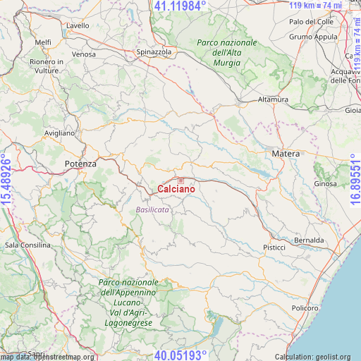
Calciano GPS coordinates[2]
40° 35' 16.872" North, 16° 11' 32.568" East
| Map corner | latitude | longitude |
|---|---|---|
| Upper-left | 41.11984°, | 15.48926° |
| Center: | 40.58802°, | 16.19238° |
| Lower-right: | 40.05193°, | 16.89551° |
| Map W x H: | 118.7×118.7 km | = 73.8×73.8mi |
| max Lat: | 47.04031° ⇑83.5% North |
| Calciano: | 40.58802° |
| min Lat: | ⇓16.5% South 35.50142° |
| min Long | Calciano | max Long |
| 6.69888° | 16.19238° | 18.48682° |
| W 94.3%⇐ | ⇒5.7% E |
Elevation
Elevation of Calciano is 429 m = 1407 ft, and this is 122.3 m = 401 ft above average elevation for this country.
| Max E: |
2085 m = 6841 ft | 26.7% |
| Calciano | 429 m 1407 ft | |
| Avg. | 306.7 m = 1006 ft | |
Min E: |
-4 m = -13 ft | 73.3% |
See also: Italy elevation on elevation.city.
Geographical zone
Calciano is located in North temperate zone (between Tropic of Cancer and the Arctic Circle). Distance of this Northern Tropic circle is 1907 km =1185 mi to South.| Distance of | km | miles | from Calciano |
|---|---|---|---|
| North Pole | 5494.1 | 3413.9 | to North |
| Arctic Circle | 2888.2 | 1794.6 | to North |
| Tropic Cancer | 1907 | 1185 | to South |
| Equator | 4513 | 2804.2 | to South |


Nearby cities:
15 places around Calciano: (largest is in red/bold)
• Accettura
11.2 km =7 mi,  195°
195°
• Albano di Lucania
13.1 km =8.1 mi,  269°
269°
• Campomaggiore
10.4 km =6.5 mi,  256°
256°
• Castelmezzano
14 km =8.7 mi,  241°
241°
• Garaguso
5.3 km =3.3 mi,  145°
145°
• Grassano
8.9 km =5.5 mi,  54°
54°
• Grottole
15.8 km =9.8 mi,  83°
83°
• Irsina
18.4 km =11.4 mi,  12°
12°
• Oliveto Lucano
5.9 km =3.7 mi,  185°
185°
• Pietrapertosa
13.5 km =8.4 mi,  234°
234°
• Salandra
12.8 km =8 mi,  122°
122°
• San Chirico Nuovo
13.8 km =8.6 mi,  316°
316°
• San Mauro Forte
12.7 km =7.9 mi,  156°
156°
• Tricarico
5.1 km =3.2 mi,  305°
305°
• Trivigno
17.2 km =10.7 mi, 267°
Sources, notices
• [Note1] Compared only with cities in Italy existing in our database
• [Src1] Map data: © OpenStreetMap contributors (CC-BY-SA)
• [Src2] Other city data from geonames.org with taken over terms of usage.
• [Src3] Geographical zone / Annual Mean Temperature by Robert A. Rohde @ Wikipedia
