Tresenda geodata
Tresenda (Lombardy) is a populated place; located in Italy in Europe/Rome (GMT+2) time zone. With population of 829 people, there are 7506 cities with bigger population in this country. Compared to other cities in Italy, 95.3% of cities are located further ↓South; 67.1% of cities are located further →East and 67.7% of cities have lower elevation than Tresenda. Note1


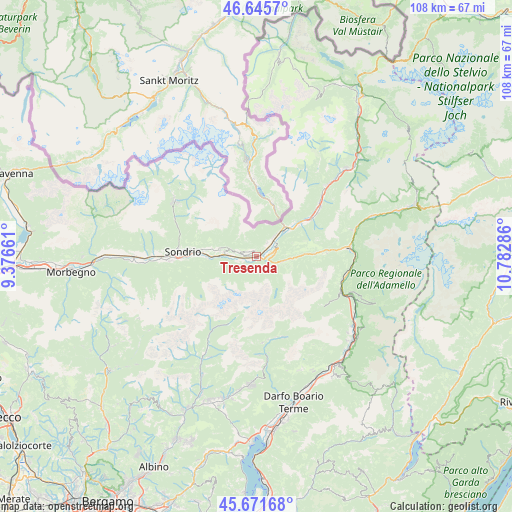
Tresenda GPS coordinates[2]
46° 9' 39.06" North, 10° 4' 47.028" East
| Map corner | latitude | longitude |
|---|---|---|
| Upper-left | 46.6457°, | 9.37661° |
| Center: | 46.16085°, | 10.07973° |
| Lower-right: | 45.67168°, | 10.78286° |
| Map W x H: | 108.3×108.3 km | = 67.3×67.3mi |
| max Lat: | 47.04031° ⇑4.7% North |
| Tresenda: | 46.16085° |
| min Lat: | ⇓95.3% South 35.50142° |
| min Long | Tresenda | max Long |
| 6.69888° | 10.07973° | 18.48682° |
| W 32.9%⇐ | ⇒67.1% E |
Elevation
Elevation of Tresenda is 371 m = 1217 ft, and this is 64.3 m = 211 ft above average elevation for this country.
| Max E: |
2085 m = 6841 ft | 32.3% |
| Tresenda | 371 m 1217 ft | |
| Avg. | 306.7 m = 1006 ft | |
Min E: |
-4 m = -13 ft | 67.7% |
See also: Italy elevation on elevation.city.
Geographical zone
Tresenda is located in North temperate zone (between Tropic of Cancer and the Arctic Circle). Distance of this North polar circle is 2268.6 km =1409.6 mi to North.| Distance of | km | miles | from Tresenda |
|---|---|---|---|
| North Pole | 4874.5 | 3028.9 | to North |
| Arctic Circle | 2268.6 | 1409.6 | to North |
| Tropic Cancer | 2526.7 | 1570 | to South |
| Equator | 5132.6 | 3189.2 | to South |


Nearby cities:
15 places around Tresenda: (largest is in red/bold)
• Aprica
5.4 km =3.4 mi,  100°
100°
• Bianzone
3.7 km =2.3 mi,  38°
38°
• Boffetto
9.6 km =6 mi,  269°
269°
• Castello dell'Acqua
5.2 km =3.2 mi,  250°
250°
• Castionetto
6 km =3.7 mi,  286°
286°
• Chiuro
7.3 km =4.5 mi,  275°
275°
• Piateda Centro
11.2 km =7 mi, 269°
• Poggiridenti Alto
11.9 km =7.4 mi, 277°
• Poggiridenti Piano
11.8 km =7.3 mi, 274°
• Ponte in Valtellina
8 km =5 mi, 281°
• San Giacomo
4.2 km =2.6 mi, 268°
• Teglio
1.8 km =1.1 mi,  316°
316°
• Tirano
8.8 km =5.5 mi,  47°
47°
• Tresivio
10.7 km =6.6 mi, 278°
• Villa
6.3 km =3.9 mi, 41°
Sources, notices
• [Note1] Compared only with cities in Italy existing in our database
• [Src1] Map data: © OpenStreetMap contributors (CC-BY-SA)
• [Src2] Other city data from geonames.org with taken over terms of usage.
• [Src3] Geographical zone / Annual Mean Temperature by Robert A. Rohde @ Wikipedia
